esauboeck
H.O. Pub. No. 9
AMERICAN
PRACTICAL NAVIGATOR
AN EPITOME OF NAVIGTION
ORIGINALLY BY
NATHANIEL BOWDITCH, LL.D.
PUBLISHED BY THE
U.S. NAVY HYDROGRAPHIC OFFICE
UNDER THE AUTHORITY OF THE
SECRETARY OF THE NAVY

UNITED STATES
GOVERNMENT PRINTING OFFICE
WASHINGTON ; 1958
For sale by authorized Sales Agents of the U.S. Navy Hydrographic Office, also by the
Superintendent of Documents, U S. Government Printing Office Washington 25, D.C. Price $6.25
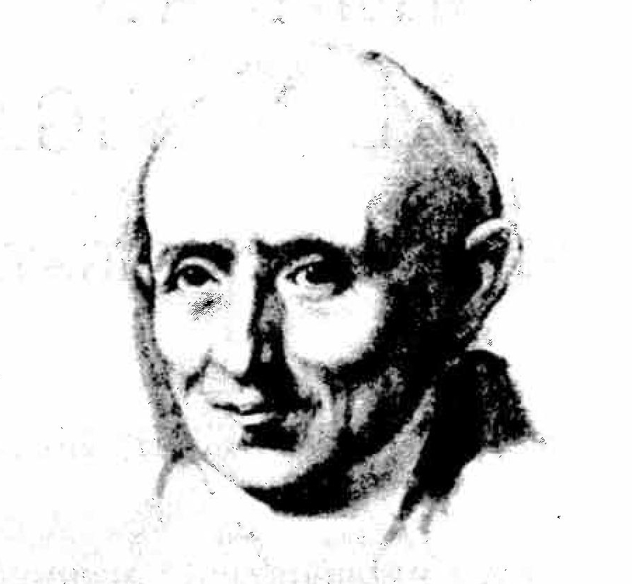

NATHANIEL BOWDITCH
Nathaniel Bowditch was born on March 26, 1773, at Salem, Mass., fourth of the seven children of shipmaster Habakkuk Bowditch and his wife, Mary.
Since the migration of William Bowditch from England to the Colonies in the 17th century, the family had resided at Salem. Most of its sons, like those of other families in this New England seaport, had gone to sea, and many of them became shipmasters. Nathaniel Bowditch himself sailed as master on his last voyage, and two of his brothers met untimely deaths while pursuing careers at sea.
It is reported that Nathaniel Bowditch's father lost two ships at sea, and by late Revolutionary days he returned to the trade of cooper, which he had learned in his youth. This provided insufficient income to properly supply the needs of his growing family, and hunger and cold were often experienced. For many years the nearly-destitute family received an annual grant of fifteen to twenty dollars from the Salem Marine Society. By the time Nathaniel had reached the age of ten, the family's poverty necessitated his leaving school and joining his father in the cooper's trade.
Nathaniel was unsuccessful as a cooper, and when he was about 12 years of age, he entered the first of two ship chandlery firms by which he was employed. It was during the nearly ten years he was so employed that his great mind first attracted public attention. From the time he began school Bowditch had an all-consuming interest in learning, particularly mathematics. By his middle teens he was recognized in Salem as an authority on that subject. Salem being primarily a shipping town, most of the inhabitants sooner or later found their way to the ship chandler, and news of the brilliant young clerk spread until eventually it came to the attention of the learned men of his day. Impressed by his desire to educate himself, they supplied him with books that he might learn of the discoveries of other men. Since many of the best books were written by Europeans, Bowditch first taught himself their languages. French, Spanish, Latin, Greek, and German were among the two dozen or more languages and dialects he studied during his life. At the age of 16 lie began the study of Newton's Principia, translating parts of it from the Latin. He even found an error in that classic, and though lacking the confidence to announce it at the time, he later published his findings and had them accepted.
During the Revolutionary War a privateer out of Beverly, a neighboring town to Salem, had taken as one of its prizes an English vessel which was carrying the phil-osophical library of a famed Irish scholar, Dr. Richard Kirwan. The books were brought to the Colonies and there bought by a group of educated Salem men who used them to found the Philosophical Library Company, reputed to have been the best library north of Philadelphia at the time. In 1791, when Bowditch was 18, two Harvard-educated ministers, Rev. John Prince and Rev. William Bently, persuaded the Company to allow Bowditch the use of its library. Encouraged by these two men and a third—Nathan Read, an apothecary and also a Harvard man—Bowditch studied the works of the great men who had preceded him, especially the mathematicians and the astronomers. By the time he became of age, this knowledge, acquired before and after his long working hours and in his spare time, had made young Bowditch the outstanding mathematician in the Commonwealth, and perhaps in the country.
In the seafaring town of Salem, Bowditch was drawn to navigation early, learning the subject at the age of 13 from an old British sailor. A year later he began studying surveying, and in 1794 he assisted in a survey of the town. At 15 he devised an almanac reputed to have been of great accuracy. His other youthful accomplishments included the construction of a crude barometer and a sundial.
When Bowditch went to sea at the age of 21, it was as captain's writer and nominal second mate, the officer's berth being offered him because of his reputation as a scholar. Under Captain Henry Prince, the ship Henrysailed from Salem in the winter of 1795 on what was to be a year-long voyage to the Ile de Bourbon (now called lie de la Reunion) in the Indian Ocean.
Bowditch began his seagoing career when accurate time was not available fo the average naval or merchant ship. A reliable marine chronometer had been invented some 60 years before, but the prohibitive cost, plus the long voyages without opportunity to check the error of the timepiece, made the large investment an impractical one. A system of determining longitude by "lunar distance," a method which did not require an accurate timepiece, was known, but this product of the minds of mathematicians and astronomers was so involved as to be beyond the capabilities of the uneducated seamen of that day. Consequently, ships navigated b y a combination of dead reckoning and parallel sailing (a system of sailing north or south to the latitude of the destination and then east or west to the destination).
To Bowditch, the mathematical genius, computation of lunar distances was no mystery, of course, but he recognized the need for an easier method of working them in order to navigate ships more safely and efficiently. Through analysis and observation, he derived a new and simplified formula during his first trip, a formula , which was to open the book of celestial navigation to all seamen.
John Hamilton Moore's The Practical Navigator was the leading navigational text when Bowditch first went to sea, and had been for many years. Early in his first voyage, however, the captain's writer-second mate began turning up errors in Moore's book, and before long he found it necessary to recompute some of the tables he most often used in working his sights. Bowditch recorded the errors he found, and by the end of his second voyage, made in the higher capacity of supercargo, the news of his findings in The Practical Navigator had reached Edmund Blunt, a publisher at Newburyport, Mass. At Blunt's request, Bowditch agreed to correct Moore's book. The first edition of The American Practical Navigator was published in 1799, with correction of the errors Bowditch had found to that time, and with some additional information. The following year a second edition was published with additional corrections. Bowditch eventually found more than 8,000 errors in the work, however, and it was finally decided to completely rewrite the book and to publish it, under his own name. In 1802 the first edition of The New American Practical Navigator by Nathaniel Bowditch was published, and his vow to put nothing in the book he could not teach every member of his crew served to keep the work within the understanding of the average seaman. In addition to the improved method of determining longitude, Bowditch's book gave the ship's officer information on winds, currents, and tides; directions for surveying; statistics on marine insurance; a glossary of sea terms; instruction in mathematics; and numerous tables of navigational data. His simplified methods, easily grasped by the intelligent seaman willing to learn, paved the way for "Yankee" supremacy of the seas during the clipper ship era.
Two months before sailing for Cadiz on his third voyage, in 1798, Bowditch married Elizabeth Boardman, daughter of a shipmaster. While he was away, his wife died at the age of 18. Two years later, on October 28, 1800, he married his cousin, Mary Ingersoll, she, too, the daughter of it shipmaster. They had eight children.
Bowditch made a total of five trips to sea, over a period of about nine years, his last as master and part owner of the three-masted Putnam. Homeward bound from a 13month voyage to Sumatra and the Ile de France (now called Mauritius) the Putnam approached Salem harbor on December 25, 1803, during a violent snowstorm without having had a celestial observation for "a day or two." Relying upon his dead reckoning, Bowditch conned his wooden-hulled ship to the entrance of the rocky harbor, where he had the good fortune to get a momentary glimpse of the light on Baker's Island, enough to confirm his position. The Putnam proceeded in, past such hazards as "Bowditch's Ledge" (named after it great-grandfather who had wrecked his ship on the rock more than a century before) and docked safely late that evening. Word of the daring feat, performed when other masters were hove-to outside the harbor, spread along the coast and added greatly to Bowditch's reputation. He was, indeed, the "practical navigator."
His standing as a mathematician and successful shipmaster earned him a lucrative (for those times) position ashore within a matter of weeks after his last voyage. He was installed as president of a Salem fire and marine insurance company, at the age of 30, and during the 20 years he held that position the company prospered. In 1823 he left Salem to take a similar position with a Boston insurance firm, serving that company with equal success until his death.
From the time he finished the "Navigator" until 1814, Bowditch's mathematical and scientific pursuits consisted of studies and papers on the orbits of comets, applications of Napier's rules, magnetic variation, eclipses, calculations on tides, and the charting of Salem harbor. In that year, however, he turned to what he considered the greatest work of his life, the translation into English of Mecanique Celeste, by Pierre Laplace. Il Mécanique Céleste was a summary of all the then known facts about the workings of the heavens. Bowditch translated four of the five volumes before his death, and published them at his own expense. He gave many formula derivations which Laplace had not shown, and also included further discoveries following the time of publication. His work made this information available to American astronomers and enabled them to pursue their studies on the basis of that which was al ready known. Continuing his style of writing for the learner, Bowditch presented his English version of Mécanique Céleste in such a manner that the student of mathematics could easily trace the steps involved in reaching the most complicated conclusions.
Shortly after the publication of The New American Practical Navigator, Harvard College honored its author with the presentation of the honorary degree of Master of Arts, and in 1816 the college made him an honorary Doctor of Laws. From the time the Harvard graduates of Salem first assisted him in his studies, Bowditch had a great interest in that college, and in 1810 he was elected one of its Overseers, a position he held until 1826, when he was elected to the Corporation. During 1826-27 he was the leader of a small group of men who saved the school from financial disaster by forcing necessary economies on the college's reluctant president. At one time Bow-ditch was offered a Professorship in Mathematics at Harvard but this, as well as similar offers from West Point and the University of Virginia, he declined. In all his life he was never known to have made a public speech or to have addressed any large group of people.
Many other honors came to Bowditch in recognition of his astronomical, mathematical, and marine accomplishments. He became a member of the American Academy of Arts and Sciences, the East India Marine Society, the Royal Academy of Edinburgh, the Royal Society of London, the Royal Irish Academy, the American Philosophical Society, the Connecticut Academy of Arts and Sciences, the Boston Marine Society,the Royal Astronomical Society, the Palermo Academy of Science, and the Royal Academy of Berlin.
Nathaniel Bowditch outlived all of his brothers and sisters by nearly 30 years. Death came to him March 16, 1838, in his sixty-fifth year. The following eulogy by the Salem Marine Society indicates the regard in which this distinguished American was held by his contemporaries:
In his death a public, s national, a human benefactor has departed. Not this community nor our country alone, but the whole world has reason to do honor to his memory. When the voice of eulogy shall be still, when the tears of sorrow shall cease to flow, no monument will be needed to keep alive his memory among men; but as long as ships shall sail, the needle point to the north, and the stars go through their wonted courses in the heavens, name of Dr. Bowditch will be revered as of one who has helped his fellow men in time of need, who was and is a guide to them over the pathless oceans, and one who forwarded the great interest of mankind.The New American Practical Navigator was revised by Nathaniel Bowditch several times after 1802 for subsequent editions of the book. After his death, Jonathan Ingersoll Bowditch, a son who made several voyages, took up the work and his name appeared on the title page from the eleventh edition through the thirty-fifth, in 1867. In 1868 the newly-organized U. S. Navy Hydrographic Office bought the copyright and has published the book since that time, revisions being made front time to time to keep the work in step with navigational improvements. The name has been altered to the American Practical Navigator, Hydrographic Office Publication No. 9, but the book is still commonly known as "Bowditch." A total of more than 700,000 copies has been printed in about 70 editions during the more than a century and a half since the book was first published in 1802. It has lived because it has combined the best thoughts of each generation of navigators, who have looked to it as their final authority.
In this extensively revised edition, the U.S. Navy Hydrographic Office has included timely information consistent with modern practices and techniques. The text has been completely rewritten. Since a primary objective has been to provide a reference publication, some duplication exists, cross-referencing is extensive, and the index is detailed. All illustrations are new. Color has been added where it serves a useful purpose. Practice problems have been included with some chapters. Selected references have been given where complete coverage would be inappropriate.
The appendix has been enlarged, and the table arrangement improved. Certain tables of previous editions have been omitted, some of those retained have been altered, and new ones have been added.
The intent of the original author to provide a compendium of navigational material understandable to the mariner has been consistently followed. However, navigation is not presented as a mechanical process to be followed blindly. Rather, emphasis has been given to the fact that the aids provided by science can be used effectively to improve the art of navigation only if a well-informed person of mature judgment and experience is on hand to interpret information as it becomes available. Thus, the facts needed to perform the mechanics of navigation have been supplemented with additional material intended to help the navigator acquire perspective in meeting the various needs that arise.
Many institutions, organizations, groups, and individuals have assisted in the preparation of this publication, but all of the material has been edited by one individual to assure continuity and consistency. Particular acknowledgment is given the following: Mr. Charles L. Petze, Jr. for assistance in preparation of chapter 1; the U.S. Navy Bureau of Ships for information relating to chapters VI and VII; the U.S. Naval Research Laboratory for review of part three; the U.S. Naval Observatory for information relating to chapter XIV and for suggestions relating to appendices F, H, I, and X the Corps of Engineers of the U.S. Army for assistance in preparation of chapter XXVII; the U.S. Coast and Geodetic Survey of the Department of Commerce for preparation of chapter XXXI, and for providing information on geomagnetism and data for appendix M and most of table 5; the U.S. Weather Bureau for assistance in preparation of part seven and tables 16 and 17; the National Bureau of Standards of the Department of Commerce for assistance in preparation of appendix D; the U.S. Naval Institute for permission to use modified versions of work forms published in Dutton's Navigation and Nauticad Astronomy (copyrighted 1943, 1948, 1951); the U.S. Power Squadrons for suggestions relating to the graph of article 924 for height of tide determination, navigation of small craft (art. 2310), and table 3; and many individuals, especially experienced practicing navigators, who have offered constructive suggestions or directed attention to errors in previous editions.
Frontispiece
Nathaniel Bowditch (1773-1838)
Preface
PART ONE: FUNDAMENTALS
History of Navigation
Basic Definitions
Chart Projections
Charts and Publications
The Nautical Chart
PART TWO: PILOTING AND DEAD RECKONING
Instruments for Piloting and Dead Reckoning
Compass Error
Dead Reckoning Piloting
PART THREE: ELECTRONIC NAVIGATION
Radio Waves
Electronics and Navigation
Direction and Distance by Electronics Hyperbolic Systems
PART FOUR: CELESTIAL NAVIGATION
Navigational Astronomy
Instruments for Celestial Navigation
Sextant Altitude Corrections
Lines of Position from Celestial Observations
The Almanac
Time
Sight Reduction
Comparison of Various Methods of Sight Reduction
Identification of Celestial Bodies
PART FIVE: THE PRACTICE OF NAVIGATION
Submarine Navigation
Polar Navigation
Lifeboat Navigation
Land Navigation
Air Navigation
Navigational Errors
PART SIX: OCEANOGRAPHY
The Oceans
Tides and Tidal Currents
Ocean Currents
Ocean Waves
Amphibious Operations
Sound in the Sea
Ice in the Sea
PART SEVEN: WEATHER
Weather Observations
Weather and Weather Forecasts
Tropical Cyclones
PART EIGHT: THE PRODUCTION OF CHARTS
Instruments for Hydrographic Surveying
Hydrographic Surveying
Oceanic Soundings
Photogrammetry
Production of Nautical Charts
APPENDICES
Abbreviations and Symbols
Greek Alphabet
Glossary
Miscellaneous Data
Navigational Coordinates
Identification of Navigational Stars
Navigational Stars and the Planets
Constellations
Buoyage Systems
Chart Symbols
Units of Depth Measurement on Charts of Various Natious
Tidal Datums in Use in Various Areas
Sources of Charts and Publications
Mathematics
Interpolation
Work Forms
Beaufort Scale
Maritime Positions
Extracts from Tide Tables
Extracts from Tidal Current Tables
Extracts from Nautical Almanac
Extracts from Air AlmanacLong-term Almanac
Extracts from H.0. Pub. No. 71
Extracts from H.0. Pub. No. 120
Extracts from H.0. Pub. No. 214
Extracts from H.0. Pub. No. 221
Extracts from H.0. Pub. No. 249
TABLES
Explanation of Tables
Conversion Angle
Conversion of Compass Points to Degrees
Traverse Table
Conversion Table for Meridional Parts
Meridional Parts
Length of a Degree of Latitude and Longitude
Distance of an Object by Two Bearings
Distance of the Horizon
Distance by Vertical Angle
Direction and Speed of True Wind in Units of Ship's Speed
Correction of Barometer Reading for Height Above Sea Level
Correction of Barometer Reading for Gravity
Correction of Barometer Reading for Temperature
Conversion Table for Millibars, Inches of Mercury, and Millimeters of Mercury
Conversion Table for Thermometer Scales
Relative Humidity
Dew Point
Speed Table for Measured Mile
Speed, Time, and Distance
Conversion Table for Nautical and Statute Miles
Conversion Table for Meters, Feet, and Fathoms
Dip of the Sea Short of the Horizon
Altitude Correction for Air Temperature
Altitude Correction for Atmospheric Pressure
Meridian Angle and Altitude of a Body on the Prime Vertical Circle
Latitude and Longitude Factors
Amplitudes
Correction of Amplitude as Observed on the Visible Horizon
Altitude Factor
Change of Altitude in Given Time from Meridian Transit Natural Trigonometric Funcions
Logarithms of Numbers
Logrithms of Trigonometric Functions
Haversines
INDEX
Chapter 1: HISTORY OF NAVIGATION
Introduction
101. Background. — Navigation began with the first man. One of his first conscious acts probably was to home on some object his eye, and thus land navigation was undoubtedly the earlier form. His first venture upon the waters may have come shortly after he observed that some objects float, and through curiousity or an attempt at self-preservation which he learned that a larger object, perhaps a log, would support him. Marine navigation was born when he attempted to guide his craft. Air navigation by men, of course, came much later.
The earliest marine navigation was a form of piloting, which came into being as man became familiar with landmarks and used them as guides. Dead reckoning probably came next as he sought to predict his future positions, or perhaps as he bravely ventured farther from landmarks. Celestial navigation, as it is known today, had to await acquisition of information regarding the motions of the heavenly bodies, although these bodies were used to steer by almost from the beginning. Electronic navigation is the modern application of a different form of energy to solve an old problem, its principal use being to extend the range of piloting.
102. From art to science. — Navigation is the process of directing the movements of a craft from one point to another. To do this safely is anart. In perhaps 6,000 years — some writers make it 8,000 — man has transformed this art almost into a science, and navigation today is so nearly a science that the inclination is to forget that it was ever any elsde. It is commonly thought that to navigate a ship one must have a chart to determine the course and distance, a compass to steer by, and a means of determining the, positions of the ship during the passage. Must have? The word "must" betrays how dependent the modern navigator has become upon the tools now in his hands. Many of the great voyages of history — voyages that made known much of the world — were made without one or more of these "essentials."
103. Epic voyages. — History records a number of great voyages of varying navigational significance. Little or nothing is known of the navigational accomplishments of the ancient mariners, but record of the knowledge and equipment used during later voyages serves to illustrate periodic developments in the field.
104. Pre-Christian navigation. — Down through the stream of time a number of voyages have occurred without navigational significance. Noah's experience in the ark is of little interest navigationally, except for his use of a dove to locate land. There is evidence to support the view that at least some American Indians reached these shores by sea, the earliest of several groups probably having come about 2200 B.C., the approximate time that a general exodus seems to have occurred from a center in south eastern Asia. This is about the time the Tower of Babel is believed to have been built. It is noteworthy that almost every land reached by the great European explorers was already inhabited.
It is not difficult to understand how a people not accustomed to the sea might make a single great voyage without contributing anything of significance to the advancement of navigation. Not so clear, however, is the fact that the Norsemen and the Polynesians, great seafaring people, left nothing more than conflicting traditions of their methods. The reputed length of the voyages made by these people suggest more advanced navigational methods than their records indicate. Although the explanation may be that they left few written accounts of any kind. Or perhaps thay developed thier powers of perception to such an extent that navigation, to them, was a highly advanced art. In this respect their navigation may not have differed greatly from that of some birds, insects, fishes, and animals.
One of the earliest well-recorded voyages is known today through the book of observations written by Pytheas of Massaliea, a Greek astronomer and navigator. Sometime between the years 350 BC and 300 BC he sailed from a Mediterranean port and followed an established trade route to England. From there he ventured north to Scotland and Thule, the legendary land of the midnight sun. He went on to explore Norwegian fiords, and rivers in northwest Germany. He may have made his way into the Baltic.
105. Sixteenth century navigation. — So the 16th century navigator had crude charts of the known world, a compass to steer by, instruments with which he could determine his latitude, a log to estimate speed, certain sailing directions, and solar and traverse tables. The huge obstacle to be overcome was an accurate method of determining longitude. 106. Eighteenth century navigation. — Little is known today of the "timepieces" carried by Magellan, but surely they were not used to determine longitude. Two hundred years later, however, the chronometer began to emerge. With it, the navigator, for the first time was able to determine his longitude accurately and fix his position at sea.
The three voyages of discovery
made by James Cook of the Royal Navy in the Pacific Ocean
between 1768 and 1779 may be said to mark the dawn of modern
navigation. Cook's expedition had the full backing of
England's scientific organizations, and he was the first
captain to undertake extended explorations at sea with
navigational equipment, techniques, and knowledge that might
be considered modern.
On his first voyage Cook was provided with an astronomical
clock, a "journeyman" clock, and a wa t eh lent by the
Astronomer Royal. With these he could determine longitude,
using the long and tedious lunar distance method. On his
second voyage four chronometers were provided. These
instruments, added to those already possessed by t lie
mariner, enabled Cook to navigate his vessels with a
precision undreamed of by Pytheas and Magellan.
By the time Cook began his
explorations, astronomers had made great contributions to
navigational astronomers and the acceptance of the
heliocentric theory of the universe had led to the
publication of the first, official nautical almanac. Chink
had progressed steadily, and adequate projections were
available. With increased understanding of variation, the
compass had become reliable. Good schools of navigation
existed, and textbooks which reduced the mathematics of
navigation to the essentials had been published. Speed
through the water could be determined with reasonable
accuracyu by the logs then in use. Most imporant, the
first chronometers were being produced.
107.
Twentieth century navigation. — The maden voyage of
the SS United States
in July 1952 served to illustrate the progress made in
navigation during the 175 years since Cook's vayages.
Outstanding because of its record trans-=Atlantic passage,
the vessel is of interest navigationally in that it carried
the most modern equipemtn available and exemplified the fact
that navigation had become nearly a science.
Each of the deck officers owned a sextant with which he could make observations more accurately than did Cook. Reliable chronometers, the product of hundreds of years of experimental work, were available to determine the time of each observation. The gyro compass indicated true north regardless of variation and deviation. Modern, convenient almanacs were used to obtain the coordinates of various celestial bodies, to an accuracy greater than needed. Easily used altitude and azimuth tables gave the navigator data for determining his Sumner (celestial) line of position by the method of Marcq St.-Hilaire. Accurate charts were available for the waters plied, sailing directions for coasts and ports visited, light lists giving the characteristics of the various aids to navigation along these coasts, and pilot charts and navigational texts for reference purposes.
Electronics served the navigator in a number of ways. Radio time signals and weather reports enabled him to check his chronometers and avoid foul weather. A radio direction finder was available to obtain bearings, and a radio telephone was used to communicate with persons on land and sea. The electrically-operated echo sounder indicated the depth of water under the keel, radar the distances and bearings of objects within range, even in the densest fog. Using loran, the navigator could fix the position of his ship a thousand miles and more from transmitting stations.
Piloting and Dead Reckoning
108. Background. — The history of piloting and dead reckoning extends from man's earliest use of landmarks to the latest model of the gyro compass. In the thousands of years between, navigation by these methods has progressed from short passages along known coast lines to transoceanic voyages during which celestial observations cannot be, or are not, made.109. Charts. — A form of sailing directions was written several hundred years before Christ. Although charts cannot be traced back that far, they may have existed during the same time. From earliest times men have undoubtedly known that it is more difficult to explain how to get to a place than it is to draw a diagram, and since the first charts known are comparatively accurate and cover large areas, it seems logical that earlier charts served as guides for the cartographers.
Undoubtedly, the first charts were not made on any "projection" (ch. III) but were simple diagrams which took no notice of the shape of the earth. In fact, these "plane" charts were used for many centuries after chart projections were available.
The gnomonic projection (art. 317) is believed to have been developed by Thales of Miletus (640-546 BC), who was chief of the Seven Wise Men of ancient Greece; founder of Greek geometry, astronomy, and philosophy; and a navigator and cartographer. The size of the earth was measured at least as early as the third century BC, by Eratosthenes. He observed that at noon on the day of the summer solstice, a certain well at Syene (Assuan) on the tropic of Cancer was lighted throughout its depth by the light of the sun as it crossed the meridian; but that at Alexandria, about 500 miles to the north, shadows were cast by the sun at high noon. He reasoned that this was due to curvature of the earth, which must be spherical. By means of the shadow of an object of known height at Alexandria, Eratosthenes determined the zenith distance to be about 7°5, or of the earth's circumference. The earth must therefore be 48X 500=24,000 (statute) miles. The correct value is about 24,900 statute miles.
Eratosthenes is believed to have been the first person to measure latitude, using the degree for this purpose. He constructed a 16-point wind rose, prepared a table of winds, and recognized local and prevailing winds. From his own discoveries and from information gleaned from the manuscripts of mariners, explorers, land travelers, historians, and philosophers, he wrote an outstanding description of the known world, which helped elevate geography to the status of a science.
Stereographic (art. 318) and orthographic (art. 319) projections were originated by Hipparchus in the second century BC.
Ptolemy's World Map. The Egyptian Claudius Ptolemy was a second century AD astronomer, writer, geographer, and mathematician who had no equal in astronomy until the arrival of Copernicus in the 16th century. An outstanding cartographer, for his time, Ptolemy constructed many charts and listed the latitudes and longitudes, as determined by celestial observations, of the places shown. As a geographer, however, he made his most serious mistake. Though Eratosthenes' calculations on the circumference of the earth were available to him, he took the estimate of the Stoic philosopher, Posidonius (circa 130-51 BC), who calculated the earth to be 18,000 miles in circumference. The result was that those who accepted his work—and for many hundreds of years few thought to question it—had to deal with a concept that was far too small. In 1409 the Greek original of Ptolemy's Cosmoyraphia, a book in which he declared this doctrine, was discovered and translated into Latin. It served as the basis for future cartographic work, and so it was that Columbus died convinced that he had found a shorter route to the East Indies. Not until 1669, when Jean Picard computed the circumference of the earth to be 24,500 miles, was a more accurate figure generally used.
Ptolemy's map of the world (fig. 109a) was a great achievement, however. It was the original conic projection, and on it he located some 8,000 places by latitude and longitude. It was he who fixed the convention that the top of the map is north.

Figure 109a. The world, as envisioned by Ptolemy about AD 150. This chart was prepared in 1482 by Nicolaus Germanus for a translation of Cosmographia.

Figure 109b. A 14th-century Portolan chart.
Asian Charts. Through the Dark
Ages some progress was made. Moslem cartographers as well
as astronomers took inspiration from Ptolemy. However,
they knew that Ptolemy had overestimated the length of the
Mediterranean by some 200. Charts of the Indian Ocean,
bearing horizontal lines indicating parallels of latitude,
and vertical lines dividing the seas according to the
direction of the wind, were drawn by Persian and Arabian
navigators. The prime meridian separated a windward from a
leeward region and other meridians were drawn at intervals
indicating "three hours sail." This information, though
far from exact, was helpful to the sailing ship masters.
Portolan Charts. — The mariners of
Venezia (Venice), Livorno(Leghorn), and Genova (Genoa)
must have had charts when they competed for Mediterranean
trade before, during, and after the Crusades. Venice at
one time had 300 ships, a navy of 45 galleys, and 11,000
men engaged in her maritime industry. But perhaps the
rivalry was too keen for masters carelessly to leave
charts lying about. At any rate, the earliest useful
charts of the Middle Ages that are known today were drawn
by seamen of Catalonia (now part of Spain).
The Portolan charts were constructed from the knowledge
acquired by seamen during their voyages about the
Mediterranean. The actual courses and dead reckoning
distances between land points were used as a skeleton for
the charts, and the coasts between were "usually filled in
from data obtained in land surveys. After the compass came
into use, these charts became quite accurate. Some, for
example, indicated the distance between Gibraltar and
Bayrft (Beirut) to be 3,000 Portolan miles, or 40°5 of
longitude. The actual difference of longitude is 40 08.
These charts were distinguished by a group of long rhumb
lines intersecting at a common point, surrounded by eight
or 16 similar groups of shorter lines. Later Portolanis
had a arse dei vent& (rose of the winds), the
forerunner of the compass rose, superimposed over the
center (fig. bob). They carried a scale of miles, located
nearly all the known hazards to navigation, and had
niunerous notes of interest to the pilot. They were not
marked with parallels of latitude or meridians of
longitude, but present-day harbor and coastal charts trace
their ancestry directly to them.
Padrón Real. The
growing habit of assembling information for charts took
concrete form in the Padrón
Real. This was the pattern, or master, map kept
after 1508 by the Casa
de Contratación at Seville. It was intended to
contain everything known about the world, and it was
constructed from facts brought back by mariners from
voyages to newly-discovered lands. From it were drawn the
charts upon which the explorers of the Age of Discovery
most depended.
World maps of the Middle
Ages. In 1515 Leonardo da Vinci drew his famous
map of the world. On it, America is represented as
extending more to the east and west than to the north and
south, with only a chain of islands, the largest named
Florida, between it and South America. A wide stretch of
ocean is shown between South America and Terra Australis Nondum
Cognita, the mythical south-seas continent whose
existence in the position shown was not disproved until
250 years later.

The Mercator projection (art. 305). For hundreds, perhaps' thousands, of years cartographers drew their charts as "plane" projections, making no use of the discoveries of Ptolemy and Hipparchus. As the area of the known world increased, however, the attempt to depict that larger area on the flat surface of the plane chart brought map makers to the realization that allowance would have to be made for the curvature of the earth.
Gerardus Mercator (Latinized form of Gerhard Kremer) was a brilliant Flemish geographer who recognized the need for a better method of chart projection. In 1569 he published a world chart which he had constructed on the principle since known b y his name. The theory of his work was correct, but Mercator made errors in his computation, and because he never published a complete description of the mathematics involved, mariners were deprived of the full advantages of the projection for another 30 years.
Then Edward Wright published the results of his own independent study in the matter, explaining the Mercator projection fully and providing the table of meridional parts which enabled all cartographers to make use of the principle.
Wright was a mathematician at Carus College who developed the method and table and gave them totertain navigators for testing. After these proved their usefulness, Wright decided upon publication, and in 1599 Certaine Errors in Navigation Detected and Corrected was printed.
The Lambert projections. Johann Heinrich Lambert, 1728-1777, self-educated son of an Alsace tailor, designed a number of map projections. Some of these are still widely used, the most renowned being the Lambert conformal (art. 314).
110. Sailing directions. — From earliest times there has been a demand for knowledge of what lay ahead, and this gave rise to the early development of sailing directions.
The Periplus of Scylax, written sometime between the sixth and fourth centuries BC, is the earliest known book of this type. Surprisingly similar to modern sailing directions, it provided the mariner with information on distances between ports, aids and dangers, port facilities, and other pertinent matters. The following excerpt is typical:
Libya begins beyond the Canopic mouth of the Nile. . . . The first people in Libya are the Adrymachidae. From Thonis the voyage to Pharos, a desert island (good harbourage but no drinking water), is 150 stadia. In Pharos are many harbors. But ships water at the Marian Mere, for it is drinkable. . . . The mouth of the bay of Plinthine to Leuce Acte (the white beach) is a day and night's sail; but sailing round by the head of the bay of Plinthine is twice as long.
Parts Around the World, Pytheas' book of observations made during his epic voyage in the fourth century BO, was another early volume of sailing directions. His rough estimates of distances and descriptions of coast lines would be considered crude today, but they served as an invaluable aid to navigators who followed him into these otherwise unknown waters.
Sailing directions during the Renaissance. No particularly noteworthy improvements were made in sailing directions during the Middle Ages, but in 1490 the Portolano Rizo was published, the first of a series of improved design. Other early volumes of this kind appeared in France and were called "routiers" — the rutters of the English sailor. In 1557 the Italian pilot Battista Testa Rossa published Brieve Compendio del Arte del Navigar, which was designed to serve the mariner on soundings and off. It forecast the single, all-inclusive volume that was soon to come, the Waggoner.
About. 1584 the Dutch pilot Lucas Jans Loon Waghenaer published a volume of navigational principles, tables, charts, and sailing directions which served as a guide for such books for the next 200 years. In Speighel der Leevaeret (The Mariner's Mirror), Waghenaer gave directions and charts for sailing the waters of the Low Countries and later a second volume was published covering waters of the North and Baltic seas.
These"Waggoners" met with great success and in 1588 an English translation of the original book was made by Anthony Ashley. During the next 30 years, 24 editions of the book were published in Dutch, German, Latin, and English. Other authors followed the profitable example set by Waghenaer, and American, British, and French navigators soon had "Waggoners" for most of the waters they sailed.
The success of these books and the resulting competition among authors were responsible for their eventual discontinuance. Each writer attempted to make his work more inclusive than any other (the 1780 Atlantic Neptune contained 257 charts of North : America alone) and the result was a tremendous book difficult to handle. They were too bulky, the sailing directions were unnecessarily detailed, and the charts too large. In 1795 the British Hydrographic Department was established, and charts and sailing directions were issued separately. The latter, issued for specific waters, were returned to the form of the original Periplus.
Modern sailing directions. The publication of modern sailing directions by the U.S. Navy Hydrographic Office is one of the achievements properly attributed to Matthew Fontaine Maury. During the two decades he headed the institution, Maury gathered data that led directly to the publication of eight volumes of sailing directions. Today there are more than 70 volumes providing the mariner with detailed information on almost all foreign coasts, in addition to ten volumes of coast pilots of the United States and its possessions, published by the U.S. Coast and Geodetic Survey.
111. The compass. — Early in the history of navigation man noted that the pole star (it may have been a Draconis then) remained close to one point in the northern sky. This served as his compass. When it was not visible, he used other stars, the sun and moon, winds, clouds, and waves. The development of the magnetic compass, perhaps a thousand years ago, and the 20th century development of the gyro compass, offer today's navigator a method of steering his course with an accuracy as great as he is capable of using.
The magnetic compass (art. 623) is one of the oldest of the navigator's instruments. Its origin is not known. In 203 BC, when Hannibal set sail from Italy, his pilot was said to be one Pelorus. Perhaps the compass was in use then; no one can say for certain that it was not. There is little to substantiate the story that the Chinese invented it, and the legend that Marco Polo introduced it into Italy in the 13th century is almost certainly false. It is sometimes stated that the Arabs brought it to Europe, but this, too, is unlikely. Probably it was known first in the west. The Norsemen of the 11th century were familiar with it, and about 1200 a compass used by mariners when the pole star was hidden was described by a French poet, Guyot de Provins.
A needle thrust through a straw and floated in water in a container comprised the earliest compass known. A 1248 writer, Hugo de Bercy, spoke of a new compass construction, the needle "now" being supported on two floats. Petrus Peregrinus de Maricourt, in his Epistola de Magneto of 1269, wrote of a pivoted floating compass with a lubber's line, and said that it was equipped with sights for taking bearings.
The reliability of the magnetic compass of today is a comparatively recent achievement. As late as 1826 Peter Barlow reported to the British Admiralty "half of the compasses in the Royal Navy were mere lumber, and ought to be destroyed." Some 75 years ago, Lord Kelvin developed the Admiralty type compass used today.
The compass card, according to tradition, had its beginning when Flavin Gioja, of Amalfi, attached a sliver of lodestone, or a magnetized needle, to a card about the beginning of the 14th century. But, the rose on the card is probably older than the needle. It is the wind rose of the ancients. Primitive man naturall y named directions by the winds. The prophet Jeremiah speaks of the winds from the four quarters of heaven (Jer. 49:36) and Homer named four winds---Boreas, Eurus, Notus, and Lephyrus. Aristotle is said to have suggested a circle of 12 winds, and Eratosthenes, who measured the world correctly, reduced the number to eight about 200 BC. The "Tower of Winds" at Athens, built about 100 BC, had eight sides. The Latin rose of 12 points was common on most compasses used in the Middle Ages.
Variation (art. 709) was well understood 200 years ago, and navigators made allowance for it, but earliest recognition of its existence is not known. Columbus and even the 11th century Chinese have been given credit for its discovery, but little proof can be offered for either claim.
The secular change in variation was determined by a series of magnetic observations made at Limehouse, England. In 1580 William Borough fixed the variation in that area at approximately 11°25' east. Thirty-two years later Edmund Gunter, professor of astronomy at Gresham College, determined it to be 6°13' east. At first it was believed that Borough had made an error in his work, but in 1633 a further decrease was found, and the earth's changing magnetic field was established.
A South Atlantic expedition was led by Edmond Halley at the close of the 17th century to gather data and to map, for the first time, lines of variation. In 1724 George Graham published his observations in proof of the diurnal change in variation. Canton determined that the change was considerably less in winter than in summer, and about 1785 the strength of the magnetic force was shown by Paul de Lamanon to vary in different places.
The existence of deviation (art. 709) was known to John Smith in 1627 when he wrote of the "bittacle" as being a "square box nailed together with wooden pinnes, because iron nails would attract the Compasse." But no one knew how to correct a compass for deviation until Captain Matthew Flinders, while on a voyage to Australia in HMS Investigator in 1801-02, discovered a method of doing so. Flinders did not understand deviation completely, but the vertical bar he erected to correct for it was part of the solution, and the Flinders bar (art. 720) used toda y is a memorial to its discoverer. Between 1839 and 1855 Sir George Airy, then Astronomer Royal, studied the matter further and developed combinations of permanent magnets and soft iron masses for adjusting the compass. The introduction, by Lord Kelvin, of short needles as compass magnets made adjustment more precise.
The gyro compass (art. 631). The age of iron ships demanded a compass which could be relied upon to indicate true north at all times, free from disturbing forces of variation and deviation.
In 1851, at the Pantheon in Paris, Leon Foucault performed his famous pendulum experiment to demonstrate the rotation of the earth. Foucault's realization that the swinging pendulum would maintain the plane of its motion led him, the following year, to develop and name the first gyroscope, using the principle of a common toy called a "rotascope." Handicapped by the lack of a source of power to maintain the spin of his gyroscope, Foucault used a microscope to observe the indication of the earth's rotation during the short period in which his manually-operated gyroscope remained in rotation. A gyro compass was not practical until electric power became available, more than 50 years later, to maintain the spin of the gyroscope.
Elmer A. Sperry, an American, and Anschutz-Kampfe, a German, independently invented gyro compasses during the first decade of the 20th century. Tested first in 1911 on a freighter operating off the East Coast of the United States and then on American warships, Sperry's compass was found adequate, and in the years following World War I gyro compasses became standard equipment on all large naval and merchant ships.
Gyro compass auxiliaries commonly used today were added later. These include gyro repeaters, to indicate the vessel's heading at various locations; gyro pilots, to steer vessels automatically; course recorders, providing a graphic record of courses steered; gyro-magnetic compasses, which repeat headings of magnetic compasses so located as to be least affected by deviation; and others in the fields of fire control, aviation, and guided missiles.
112. The log. — Since virtually the beginning of navigation, the mariner has attempted to determine his speed in traveling from one point to another. The earliest method was probably by estimate.
The oldest speed measuring device known is the Dutchman's log. ()rally, any object which would float was thrown overboard, on the lee side, from a point well forward, and the time required for it to pass between two points on the deck was noted. The time, as determined by sand glass, was compared with the known distance along the deck between the two points to determine the speed.
Near the end of the 16th century a line was attached to the log, and as the line was paid out a sailor recited certain sentences. The length of line which was paid out during the recitation was used to determine the speed. There is record of this method having been used as recently as the early 17th century. In its final form this chip log, ship log, or common log consisted of the log chip (or icy ship), log line, log reel, and log glass. The chip was a quadrant-shaped piece of wood weighted along its circumference to keep it upright in the water (fig. 112). The log line was made fast to the log chip by means of a bridle, in such manner that a sharp pull on the log line dislodged a wooden peg and permitted the log chip to be towed horizontally through the water, and hauled aboard. Sometimes a stray line was attached to the log to veer it clear of the ship's wake. In determining speed, the observer counted the knots in the log line which was paid out during a certain time. The length of line between knots and the number of seconds required for the sand to run out were changed from time to time as the accepted length of the mile was altered.
The chip log has been superseded by patent logs that register on dials. However, the common log has left its mark on modern navigation, as the use of the term knot to indicate a speed of one nautical mile per hour dates from this device. There is evidence to support the opinion that the expression "dead reckoning" had its origin in this same device, or perhaps in the earlier Dutchman's log. There is logic in attributing "dead" reckoning to a reckoning relative to an object "dead" in the water.

FIGURE 112.—The common or chip log, showing the log reel, the log line, the log chip, and the log glass.
Mechanical logs first appeared about the middle of the 17th century. By the beginning of the 19th century, the forerunners of modern mechanical logs were used by some navigators, although many years were to pass before they became generally accepted.
In 1773 logs on which the distance run was recorded on dials secured to the taffrail were tested on board a British warship and found reasonably adequate, although the comparative delicateness of the mechanism led to speculation about their long-term worth. Another type in existence at the time consisted of a wheel arrangement made fast on the underside of the keel, which transmitted readings to a dial inside the vessel as the wheel rotated.
An improved log was introduced by Edward Massey in 1802. This log gave considerably greater accuracy by means of a more sensitive rotator attached by a short length of line to a geared recording instrument. The difficulty with this log was that it had to be hauled aboard to take each reading. Various improvements were made, notably by Alexander Bain in 1846 and Thomas Walker in 1861, but it was not until 1878 that a log was developed in which the rotator could be used in conjunction with a dial secured to the after rail of the ship, and although refinements and improvements have been made, the patent log used today is essentially the same as that developed in 1878.
Engine revolution counters (art. 615) had their origin with the observations of the captains of the first paddle steamers,, who discovered that by counting the paddle revolutions, they could, with practice, estimate their runs in thick weather as accurately as they could by streaming the log. Later developments led to the modern revolution counter on screw-type vessels, which can be used with reasonable accuracy if the propeller is submerged and an accurate estimate of slip is made.
Pitot-static and impeller-type logs (arts. 613, 614) are recent mechanical developments in the field of speed measurement. Each utilizes a retractable "rodmeter" which projects through the hull of the ship into the water. In the Pitot-static log, static and dynamic pressures on the rodmeter transmit readings to the master speed indicator. In the impeller-type log an electrical means of transmitting speed indications is used.
113. Units of distance and depth. — The modern navigator is concerned principally with three units of linear measure: the nautical mile, the fathom, and the foot (sometimes also the meter). Primitive man, however, used such natural units as the width of a finger, the span of his hand, the length of his foot, the distance from elbow to the tip of the middle finger (the cubit of biblical renown), or the pace (sometimes one but usually a double step) to measure short distances.
These ancient measurements varied from place to place, and from person to person. One of the first recorded attempts to establish a tangible standard length was made by the Greeks, who used the length of the Olympic stadium as a unit called a stadium. This was set at 600 Greek feet (607.9 modern U. S. feet), or almost exactly one-tenth of a modern nautical mile. The Romans adopted this unit and extended its use to nautical and even astronomical measurements. The Roman stadium was 625 Roman.feet, or 606.3 U. S. feet, in length. The length of the stadium approximates the modern cable, a unit of 608 feet in the British Navy and 720 feet in the U. S. Navy.
The origin of the Mediterranean mile of 4,035.42 U. S. feet is attributed to the Greeks. The Roman mile of 4,858.59 U. S. feet gradually replaced the shorter Greek unit, and was probably the value in use in Palestine when Christ in his Sermon on the Mount spoke of the "second mile" (Matt. 5:41). It is probable that the mile was given its name by the Romans, since the word is derived from the Latin mule (thousand). This unit was defined as a thousand paces. However, the Greek unit was similarly defined, as was the Arabian mile or mil of 6,000 Arabian feet, equal to 1.03 nautical miles.
The nautical mile bears little relation to these land measures, which were not associated with the size of the earth. With the emergence of the nautical chart, it became customary to show a scale of miles on the chart, and the accepted value of this unit varied over the centuries with the changing estimates of the size of the earth. These estimates varied widely, ranging from about 44.5 to 87.5 modern nautical miles per degree of latitude, although generally they were too small. Columbus and Magellan used the value 45.3. Actually, the earth is about 32 percent larger. The Almagest of Ptolemy considered 62 Roman miles equivalent to one degree, but a 1466 edition of this book contained a chart of southern Asia drawn by Nicolaus Germanus on which 60 miles were shown to a degree. Whether the change was considered a correction or an adaptation to provide a more convenient relationship between the mile and the degree is not clear, but this is the earliest known use of this ratio.
Later, when the size of the earth was determined by measurement, the relationship of 60 Roman miles of 4,858.59 U. S. feet to a degree of latitude was seen to be in error. Both possible solutions to the problem—changing the ratio of miles to a degree, or changing the length of the mile—had their supporters, and neither group was able to convince the other. As a result, the shorter mile remained as the land or statute mile (now established as 5,280 feet in the United States), and the longer nautical mile gradually became established at sea. The earliest known reference to it by this name occurred in 1730.
Finer instruments and new methods make increasingly more accurate determinations of the size of the earth an ever-present possibility. Hence, a unit of length defined in terms of the size of the earth is undesirable. Recognition of this led, in 1875, to a change in the definition of the meter from one ten-millionth of the distance from the pole to the equator of the earth to the distance between two marks (equal to 39.37 U. S. inches) on a standard platinum-iridium bar kept at the Pavilion de Breteuill at Sevres, near Paris, France, by the International Commission of Weights and Measures. In further recognition of this principle, the International Hydrographic Bureau in 1929 recommended, adoption of a standard value for the nautical mile, and proposed 1852 international meters (6,076.10333 ... U. S. feet). The United States, by concurrent action of the Departments of Defense and Commerce, adopted the international value in 1954. Nearly all major maritime nations now use this value.
The fathom as a unit of length or depth is of obscure origin, but primitive man considered it a measure of the outstretched arms, and the modern seaman still estimates the length of a line in this manner. That the unit was used in early times is indicated by reference to it in the detailed account given of the Apostle Paul's voyage to Rome, as recorded in the 27th chapter of the Acts of the Apostles. Posidonius reported a sounding of more than 1,000 fathoms in the second century BC. How old the unit was at that time is unknown.
114. Soundings. — Probably the most dangerous phase of navigation occurs when the vessel is "on soundings." Since man first began navigating the waters, the possibility of grounding his vessel has been a major concern, and frequent soundings have been the most highly valued safeguard against that experience. Undoubtedly used long before the Christian era, the lead line is perhaps the oldest instrument of navigation.
The lead line. The hand lead (art. 617), consisting of it lead weight attached to a line usually marked in fathoms, has been known since antiquity and, with the exception of the markings, is probably the same today as it was 2,000 or more years ago. The deep sea lead, a heavier weight with a longer line, was a natural outrowgth of the hand lead. A 1585 navigator speaks of soundings of 330 fathoms, and in 1773, in the Norwegian Sea, Captain Phipps had all the sounding lines on board spliced together to obtain a sounding of 683 fathoms. Matthew Fontaine Maury made his deep sea soundings by securing a cannon shot to a ball of strong twine. The heavy weight caused the twine to run out rapidly, and when bottom was reached, the twine was cut and the depth deduced from the amount remaining on the ball. .
The sounding machine. The biggest disadvantage of the deep sea lead is that the vessel must be stopped if depths are to be measured accurately. This led to the development of the sounding machine (art. 618).
Early in the 19th century a sounding machine similar to one of the earlier patent logs was invented. A wheel was secured just above the lead and the cast made in such a way that all the line required ran out freely and the lead sank directly to the bottom. The motion through the water during the descent set the wheel revolving, and this in turn caused the depth to be indicated on a dial. Ships sailing at perhaps 12 knots required 20 or 30 men to heave aboard the heavy line with its weight of 50 or more pounds after each cast. A somewhat similar device was the buoy sounder. The lead was passed through a buoy in which a spring catch was fitted and both were cast over the side. The lead ran freely until bottom was reached, when the catch locked, preventing further running out of the line. The whole assembly was then brought on board, the depth from the buoy to the lead being read.
The first use of the pressure principle to determine the depth of water occurred early in the 19th century when the "Self-acting Sounder" was introduced. A hollow glass tube open at its lower end contained an index which moved up in the tube as greater water pressure compressed the air inside. The index retained its highest position when hauled aboard the vessel, and its height was proportional to the depth of the water.
The British scientist Lord Kelvin in 1878 perfected the sounding machine after repeated tests at sea. Prior to his invention, fibre line was used exclusively in soundings. His introduction of piano wire solved the problem of rapid descent of the lead and also that of hauling it back aboard quickly. The chemically-coated glass tube which he used to determine depth was an improvement of earlier methods, and the worth of the entire machine is evidenced by the fact that it is still used in essentially the same form.
Echo sounding. Based upon the principle that sound travels through sea water at it nearly uniform rate, automatic depth-registering devices (art. 619) have been invented to indicate the depth of water under a vessel, regardless of its speed. In 1911 an account was published of an experiment performed by Alexander Behm of Kiel, who timed the echo of an underwater explosion, testing this theory. High frequency sounds in water were produced by Pierre Langevin, and in 1918 he used the principle for echo depth finding. The first practical echo sounder was developed by the United States Navy in 1922.
The actual time between emission of a sonic or ultrasonic signal and return of its echo from the bottom, the angle at which the signal is beamed downward in order that its echo will be received at another part of the vessel, and the phase difference between signal and echo have all been used in the development of the modern echo sounder.
115. Aids to navigation. — The Cushites and Libyans constructed towers along the Mediterranean coast of Egypt, and priests maintained beacon fires in them. These were the earliest known lighthouses. At Sigeum in the Troad (part of Troy) a lighthouse was built before 660 BC. One of the seven wonders of the ancient world was the lighthouse called the Pharos of Alexandria, which may have been more than 200 feet tall. It was built by Sostratus of Cnidus (Asia Minor) in the third century BC, during the reign of Ptolemy Philadelphus. The word "pharos" has since been a general term for lighthouses. Some time between 1584 and 1611 the light of Cordovan, the earliest wave-swept lighthouse, was erected at the entrance to the Gironde river in western France. An oak log fire illuminated this structure until the 18th century.
Wood or coal fires were used in the many lighthouses built along the European and British coasts in the 17th and 18th centuries. One of these, the oak pile structure erected by Henry Whiteside in 1776 to warn shipmasters of Small's Rocks, subsequently played a major role in navigational history, as it was this light which figured in the discovery of the celestial line of position by Captain Thomas Sumner some 60 years later (art. 131).
In England such structures were privately maintained by interested organizations. One of the most famous of these groups, popularly known as "Trinity House," was organized in the 16th century, perhaps earlier, when a "beaconage and buoy age" fee was levied on English vessels. This prompted the establishment of Trinity House "to make, erect, and set up beacons, marks, and signs for the sea" and to provide vessels with pilots. The organization is now in its fifth century of operation, and its chief duties are to serve as a general lighthouse and pilotage authority, and to supply pilots.
The first lightship was a small vessel with lanterns hung from its yardarms. It was stationed at the Nore, an estuary in the Thames River, England, in 1732.
The pilot's profession is not much younger than that of the mariner. The Bible relates (1 Kings 9:27) that Hiram of Tyre provided pilots for King Solomon. The duties of these pilots are not specified. In the first century AD, fishermen of the Gulf of Cambay, India, met seagoing vessels and guided them into port. It is probable that pilots were established in Delaware Bay earlier than 1756.
Seafaring people of the United States had erected lighthouses and buoys before the Revolutionary War, and in 1789 Congress passed legislation providing for federal expansion of the work. About 1767 the first buoys were placed in the Delaware River. These were logs or barrels, but about 1820 they were replaced with spar buoys. In that same year, the first lightship was established in Chesapeake Bay.
As the maritime interests of various countries grew, more and better aids to navigation were made available. In 1850 Congress prescribed the present system of coloring and numbering United States buoys (app. J). Conformity as to shape resulted from the recommendations of the International Marine Conference of 1889. The second half of the 19th century saw the development of bell, whistle, and lighted buoys, and in 1910 the first lighted buoy in the United States utilizing high pressure acetylene apparatus was placed in service. Stationed at the entrance to Ambrose Channel in New York, it provided the basis for the high degree of perfection which has been achieved in the lighted buoy since that time. The complete buoyage system maintained by the U. S. Coast Guard today is chiefly a product of the 20th century. In 1900 there were approximately 5,000 buoys of all types in use in the United States, while today there are more than 20,000.
116. The railings. — The various methods of mathematically determining course, distance, and position arrived at have a history almost as old as mathematics itself. Thales, Hipparchus, Napier, Wright, and others contributed the formulas that led to the tables permitting computation of course and distance by plane, traverse, parallel, middle-latitude, Mercator, and great-circle sailings.
Plane sailing (art. 813). Based upon the assumption that the surface of the earth is plane, or flat; this method was used by navigators for many centuries. The navigator solved problems by laying down his course relative to his meridian, and stepping off the distance run to the new position. This system is used with accuracy today in measuring short runs on a Mercator chart, which compensates for the convergence of the meridians, but on the plane chart, serious errors resulted. Early navigators might have obtained mathematical solutions to this problem, with no greater accuracy, but the graphical method was commonly used.
Traverse sailing (art. 814). Because sailing vessels were subject to the winds, navigators of old were seldom able to sail one course for great distances, and consequently a series of small triangles had to be solved. Equipment was designed to help seamen in maintaining their dead reckoning positions. The modern rough log evolved from the log board, hinged wooden boards that folded like a book and on which courses and distances were marked in chalk. Each day the position was determined from this data and entered in the ship's journal, today's smooth log.
The log board was succeeded by the travas, a board with lines radiating from the center in 32 compass directions. Regularly spaced along the lines were small holes into which pegs were fitted to indicate time run on the particular course. In 1627 John Smith described the travas as a "little round board full of holes upon lines like the compasse, upon which by the removing of a little sticke they (seamen) keepe an account, how many glasses (which are but halfe houres) they steare upon every point of the compasse."
These devices were of great value to the navigator in keeping a record of the courses and distances sailed, but still left him the long mathematical solutions necessary to determine the new position. In 1436 what appears to have been the first traverse table was prepared by Andrea Biancho. Using this table of solutions of right-angled plane triangles, the navigator was able to determine his course and distance made good after sailing a number of distances in different directions.
Parallel sailing (art. 815) was an outgrowth of the navigator's inability to determine his longitude. Not a mathematical solution in the sense that the other sailings are, it involved converting the distance sailed along a parallel (departure), as determined by dead reckoning, into longitude.
Middle-latitude sailing (art. 816). The inaccuracies involved in plane sailing led to the improved method of middle-latitude sailing early in the 17th century. A mathematician named Ralph Handsen is believed to have been its inventor. Middle-latitude sailing is based upon the assumption that the use of a parallel midway between those of departure and arrival will eliminate the errors inherent in plane sailing due to the convergence of the meridians. The assumption is reasonably accurate and although the use of Mercator sailing usually results in greater accuracy, middle-latitude sailing still serves a useful purpose.
Mercator sailing (art. 817). Included in Edward Wright's Certain Errors in Navigation Detected and Corrected, of 1599, was the first published table of meridional parts, which provided the basis for the most accurate of rhumb line sailings—Mercator sailing.
Great-circle sailing (art. 819). For many hundreds of years mathematicians have known that a great circle is the shortest distance between two points on the surface of a sphere, but it was not until the 19th century that navigators began to regularly make use of this information.
The first printed description of great-circle sailing appeared in Pedro Nunes' 1537 Tratado da Sphera. The method had previously been proposed by Sebastian Cabot in 1498, and in 1524 Verrazano sailed a great-circle course to America. But the sailing ships could not regularly expect the steady winds necessary to sail such a course, and their lack of knowledge concerning longitude, plus the necessity of stopping at islands along their routes to take supplies, made it impractical for most voyages at that time.
The gradual accumulation of knowledge concerning seasonal and prevailing winds, weather conditions, and ocean currents eventually made it possible for the navigator to plan his voyage with more assurance. Nineteenth century writers of navigational texts recommended the use of great-circle sailing, and toward the close of that century such sailing became increasingly popular, particularly in the Pacific.
The mathematics involved in great-circle sailing may be tedious, but the use of the gnomonic projection in locating points along the great-circle track has simplified the method.
117. Hydrographic offices. — The practice of recording hydrographic data was centuries old before the establishment of the first official hydrographic office, in 1720. In that year the Depot des Cartes, Plans, Journaux et Memoirs Relatifs a la Navigation was formed in France with the Chevalier de Luynes in charge. The Hydrographic Department of the British Admiralty, though not established until 1795, has played a major part in European hydrographic work.
The U. S. Coast and Geodetic Survey was originally founded when Congress, in 1807, passed a resolution authorizing a survey of the coast, harbors, outlying islands, and fishing banks of the United States. On the recommendation of the American Philosophical Society, President Jefferson appointed Ferdinand Hassler, a Swiss immigrant who had founded the Geodetic Survey of his native land, the first Director of the "Coast Survey."
The approaches to New York were the first sections of the coast charted, and from there the work spread northward and southward along the eastern seaboard. In 1844 the work was expanded and arrangements made to chart simultaneously the Gulf and Fast Coasts. Investigation of tidal conditions began, and in 1855 the first tables of tide predictions were published. The California gold rush gave impetus to the survey of the West Coast, which began in 1850, the year California became a State. The survey ship Washington undertook investigations of the Gulf Stream. Coast pilots, or sailing directions, for the Atlantic coast of the United States were privately published in the first half of the 19th century, but about 1850 the Survey began accumulating data that led to federally-produced coast pilots. The 1889 Pac{cc Coast Pilot was an outstanding contribution to the safety of West Coast shipping.
Today the U. S. Coast and Geodetic Survey, as it has been called since 1878, provides the mariner with the charts and coast pilots of all waters of the United States and its possessions. and tide and tidal current tables for much of the world.
U.S. Navy Hydrographic Office. In 1830 the U. S. Navy established a "Depot of Charts and Instruments" in Washington, D. C. Primarily, it was to serve as a storehouse where such charts and sailing directions as were available, together with navigational instruments, could be assembled for issue to Nav y ships which required them. Lieutenant L. M. Goldsborough and one assistant, Passed Midshipman R. B. Hitch-cock, constituted the entire staff.
The first chart published by the Depot was produced from data obtained in a survey made by Lieutenant Charles Wilkes, who had succeeded Goldsborough in 18:34, and who later earned fame as the leader of a United States exploring expedition to Antarctica.
From 1842 until 1861 Lieutenant Matthew Fontaine Maury served as Officer-in-Charge. Under his command the office rose to international prominence. Maury decided upon an ambitious plan to increase the mariner's knowledge of existing winds, weather, and currents. He began by making a detailed record of pertinent matter included in old log books stored at the Depot. He then inaugurated a hydrographic reporting program among shipmasters, and the thousands of answers received, along with the log book data, were first utilized to publish the Wind and Current Chart of the North Atlantic of 1847. The United States instigated an international conference in 1853 to interest other nations in a system of exchanging nautical information. The plan, which was Maury's, was enthusiastically adopted by other maritime nations, and is the basis upon which hydrographic offices operate today.
In 1854 the Depot was redesignated the "U. S. Naval Observatory and Hydro-graphical Office," and in 1866 Congress separated the two, broadly increasing the functions of the latter. The Office was authorized to carry out surveys, collect information, and print every kind of nautical chart and publication, all "for the benefit and use of navigators generally."
One of the first acts of the new Office was to purchase the copyright of The New American Practical Navigator. Several volumes of sailing directions had already been published. The first Notice to Mariners appeared in 1869. Daily broadcast of navigational warnings was inaugurated in 1907, and in 1912, following the sinking of the ,SS Titanic, Hydrographic Office action led to the establishment of the International Ice Patrol. The development by the U. S. Navy of an improved depth finder in 1922 made possible the acquisition of additional information concerning bottom topography. During the same year aerial photography was first employed as an aid in chart making.The Hydrographic Office published the first chart for lighter-than-air craft in 1923. Aerial geomagnetic surveys were instituted in 1953 to provide magnetic information for ocean areas. Since World War II various electronic means have been employed to improve and extend surveys.
Meanwhile numerous books have been published to assist the mariner and aviator in the solution of celestial observations. The initials ''H.O." preceding a publication number are familiar to most navigators.
The International Hydrographic Bureau is an organization whose purpose is to encourage world-wide uniforniity in hvdrographic procedures. From the tine of the International Marine ('onference, held at Washington, D. C. in 1889, a need for such an organization was felt, and in 1919, at the Conference held in London, a French proposal for the establishment of such a. body was adopted by delegates from the 24 nations represented. The Interualionnl H ydrographic Bureau, located at Monaco, has since served as it coordinating agency for hydrographic work throughout the world.
118. Navigation manuals. — Although navigation is as old as man himself, navigation textbooks, as they are thought of today, area product of the last several centuries. Until the end of the Dark Ages such hooks, or manuscripts, as were available were written by astronomers for other astronomers. The navigator was forced to make use of these, gleaning what little was directly applicable to his profession. After 1500, however, the need for hooks on navigation resulted in the publication of it series of manuals of increasing value to the mariner.
Sixteenth centery manuals. Frequently a command of Latin was required to study navigation during the 16th century. Regimento do estrolabio e do quadrante (fig. 130x), which was published at Lisbon in 1509, or earlier, explained the method of finding latitude by meridian observations of the sun and the pole star, contained a traverse table for finding the longitude by dead reckoning, and listed the longitudes of a number of places. Unfortunately, the author made several errors in transcribing the declination tables published by Abraham Zacuto in 1474, and this resulted in errors being made for many years in determining latitude. Nevertheless, the nameless writer of the Regimento performed a great service for all mariners. His "Handbook for the Astrolabe and Quadrant — to translate the title — had many editions and many emulators.
In 1519 Fernandez de Fncisco published his Sunia de Geographia, the first Spanish manual. The book was largely a translation of the Regimento, but new information was included, and revisions were printed in 1530 and 1546.
The Flemish mathematician and astronomer R. Gemma Frisius published a book on navigation in 1530. His manual, entitled De Principiis Astronomiae, gave an excellent description of the sphere, although the astronomy was that. of Ptolemy, and discussed at length the use of the globe in navigation. Gemma gave courses in terms of the principal winds, proposed that longitude be reckoned from the Fortunate Islands (Canary Islands), and gave rules for finding the dead reckoning position by courses and distances sailed.
Tratado do Sphera, Pedro Nunes' great work, appeared in 1537. In addition to the first printed description of great-circle sailing, Nunes' book included a section on determining the latitude by two altitudes of the sun (taken when the azimuths differed by not less than 40°), and solving the problem on a globe. The method was first proposed by Genuna. Tratado da Sphera contained the conclusion of a study of
the "plane chart" which Nunes had made. He exposed its errors, but was unable to develop it satisfactory substitute.
During the years that followed, an extensive navigational literature became available. The Spaniard Pedro de Medina and Martin Cortes published successful manuals in 1545 and 1551, respectively. Medina's Arte de Navegar passed through 13 editions in several languages and Breve de la Spera y de la Arte de Navegar, Cortes' book, was eventually translted into English and became the favorite of British navigators. Cortes discussed the priciple which Mercator used 18 years later in constructing his famous chart, and he also listed. lately the distance between meridians all latitudes.
Diego Garcia de Palacio published the first American manual at Mexico City in 1559. His Instrucion Nauthica included a partial glossary of nautical terms and certain data on ship construction.
John Davis' The Seaman's Secrets of 1594 was the first of the "practical" books. Davis was a celebrated navigator who asserted that it was the purpose of his book give "all that is necessary for sailors, not for scholars on shore." Davis' book discussed at length the navigator's instruments, and went. into detail on the "sailings." He explained the method of dividing a great circle into a number of rhumb lines, and the work he had done with Edward Wright qualified him to report on the method advantages of Mercator sailing. He endorsed the system of determining latitude by two observations of the sun and the intermediate bearing.
Although best known for the presentation of the theory of Mercator sailing, Edward Wright's Certiane Errors in Navigation Detected and Corrected (1599) was a sound navigation manual in its own right. Particularly, he advocated correcting sights for dip, refraction, and parallax (ch. XVI).
Later manuals. The next 200 years saw a succession of navigation male made available to the navigator; so many that only a few can be mentioned. Among those which enjoyed the greatest success were Blundeville's Exercises, John Napier's Mirifici Logarithmorum Canonis Constructio (which introduced the use of logarithms at sea), the tables and rules of Edmund Gunter, Arithmetical Navigation by Thomas Addison, and Richard.Norwood's The Seaman's Practices (which gave the length o: nautical mile as 6,120 feet). Robert Dudley filled four volumes in writing the Arcano del Mare ( 1646-47) as did John Robertson with Elements of Navigation. Jonas and John Moore, William Jones, and several Samuel Dunns were others who contributed navigation books before Nathaniel Bowditch in America and J. W. Norie in England wrote the manuals which navigators found best suited to their needs.

written by Nathaniel Bowditch and published in 1802.
Bowditch's The New American Practical Navigator was first published in 1802, and None's Epitome of Navigation appeared the following year. Both were standing books which enabled the mariner of little formal education to grasp essentials of his profession. The Englishman's book passed through 22 editions in that country before losing its popularity to Captain Lecky's famous "Wrinkles" in Practical Navigation of 1881. The American Practical Navigator is still read widely more than a century-and-a-half after its original printing.
A number of worthy navigation manuals have appeared in recent years.
119. Astronomy is sometimes called the oldest of sciences. The movement the sun, moon, stars, and planets were used by the earliest men as guides in hunting, fishing, and farming. The first maps were probably of the heavens.
Babylonian priests studied celestial mechanics at a very early date, possibly as early as 3800 BC, more probably about 1500 years later. These ancient astronomers predicted lunar and solar eclipses, constructed tables of the moon's hour angle, are believed to have invented the zodiac. The week and month as known to have originated with their calendar. They grouped the stars by constellations. It is probable that they were arranged in essentially their present order as early as BC. The five planets easily identified by the unaided eye were known to the Babylonians, who were apparently the first to divide the sun's apparent motion about the earth into 24 equal parts. They published this and other astronomical data in ephemerides. There is evidence that the prophet Abraham had an excellent knowledge of astromy.
The Chinese, too, made outstanding contributions to the science of the heavens. They may have fixed the solstices and equinoxes before 2000 BC. They had quadrants and armillary spheres, used water clocks, and observed meridian transits. These ancient Chinese determined that the sun made its annual apparent revolution about the earth in 365 1/4, days, and divided circles into that many parts, rather than 360. About 1100 BC the astronomer Chou Kung determined the sun's maximum declination within about 15'.
Astronomy was used by the Egyptians in fixing the dates of their religious festivals almost as early as the Babylonian studies. By 2000 BC or earlier the new year began with the heliacal rising of Sirius; that is, the first reappearance of this star in the eastern sky during morning twilight after having last been seen just after sunset in the western sky. The heliacal rising of Sirius coincided approximately with the annual Nile flood. The famous Pyramid of Cheops, which was probably built in the 17th century BC, was so constructed that the light of Sirius shone down a southerly shaft when at upper transit, and the light of the pole star shone down a northerly shaft at lower transit, the axes of the two shafts intersecting in the royal burial chamber. When the pyramid was constructed, a Draconis, not Polaris, was the pole star.
The Greeks learned of navigational astronomy from the Phoenicians. The earliest Greek astronomer, Thales, was of Phoenician ancestry. He is given credit for dividing the year of the western world into 365 days, and he discovered that the sun does not move uniformly between solstices. Thales is most popularly known, however, for predicting the solar eclipse of 585 BC, which ended a battle between the Medea and the Lydians. Be was the first of the great men whose work during the next 700 years was the controlling force in navigation, astronomy, and cartography until the Renaissance.
120. Shape of the earth. — Advanced as the Babylonians were, they apparently considered the earth to be flat. Land surveys of about 2300 BC show a "salt water river" encircling the country (fig. 120).

FIGURE 120. A Babylonian map of about 500 BC. The Babylonians believed the earth
to be a flat disk encircled by a salt water river.
But seafarers knew that the last to be seen of a ship as it disappeared over the horizon was the masthead. They recognized the longer summer days in England when they sailed to the tin mines of Cornwall, as early as 900 BC. In that "north land" the Mediterranean sailors noticed that the pole star was higher in the sky and the lower southern constellations were no longer visible. When Thales invented the
gnomonic projection, about 600 BC, he must have believed the earth to be a sphere. Two centuries later Aristotle wrote that the earth's shadow on the moon during an eclipse was always circular. Archimedes (287-212 BC) used a glass celestial globe with a smaller terrestrial globe inside it. Although the average man has understood the spherical nature of the earth for only a comparatively short period, learned astronomers have accepted the fact for more than 25 centuries.
121. Celestial mechanics. — Among astronomers the principal question for 2,000 years was not the shape of the earth, but whether it or the sun was the center of the universe. A stationary earth seemed logical to the early Greeks, who calculated that daily rotation would produce a wind of several hundred miles per hour at the equator.
Failing to realize that the earth's atmosphere turns with it, they considered the absence of such a wind proof that the earth was stationary.
The belief among the ancients was that all celestial bodies moved in circles about the earth. However, the planets — the "wanderers," as they were called — contradicted this theory by their irregular motion. In the fourth century BC Eudoxus of Cnidus attempted to account for this by suggesting that planets were attached to concentric spheres which rotated about the earth at, varying speeds. The plan of epicycles, the theory of the universe which was commonly accepted for 2,000 years, was first proposed by Apollonius of Perga in the third century BC. Ptolemy accepted and amplified the plan, explaining it in his famous books, the Almagest and Cosmographia. According
to Ptolemy, the planets moved at uniform speeds in small circles, the centers of which moved at, uniform speeds in circles about the earth (fig. 121).
At first the Ptolemaic theory was accepted without question, but as the years passed, forecasts based upon it proved to be inaccurate. By the time the Alfonsine Tables were published in the 13th century AD, a growing number of astronomers considered the Ptolemaic doctrine unacceptable. However, Purbach, Regiomontanus, Bernhard Walther of Kuremberg, and even Tycho Brahe in the latter part of the 16th
century, were among those who tried to reconcile the earth-centered epicyclic plan to the observed phenomena of the heavens.
As early as the sixth centur y BC, a brotherhood founded by Pythagoras, a Greek philosopher, proposed that the earth was round and self-supported in space, and that it, the other planets, the sun, and the moon revolved about, a central fire which they
called Hestia, the hearth of the universe. The sun and the moon, they said, shone by reflected light from Hestia.
The central fire was never located, however, and a few hundred years later Aristarchus of Samos advanced a genuine heliocentric theory. He denied the existence of Hestia and placed the sun at the center of the universe, correctly considering it to be a star which shone by itself. The Hebrews apparently understood the correct, relationship at least as early as Abraham (about 2000 BC), and the early inhabitants of the Western Hemisphere probably knew of it before the Europeans did.
The Ptolemaic theory was generally accepted until its inability to predict future positions of the planets could no longer be reconciled. Its replacement by the heliocentric theory is credited principall y to Nicolaus Copernicus (or Koppernigk). After studying mathematics at the University of Cracow, Copernicus went to Bologna, where he attended the astronomical lectures of Domenicao Maria Novara, an advocate of the Pythagorean theory. Further study in Martianus Copella's Satyricori, which includes a discussion of the heliocentric doctrine, convinced him that the sun was truly the center of the universe.
Until the year of his death Copernicus tested his belief by continual observations, and in that year, 1543, he published De Revolutiunibus Orbium Coelestium. In it he said that the earth rotated on its axis daily and revolved in a circle about the sun once each year. He placed the other planets in circular orbits about the sun also, recoguizing that Mercury and Venus were closer than the earth, and the others farther out. He concluded that the stars were motionless in space and that the moon moved circularly about the earth. His conclusions did not become widely known until nearly a century later, when Galileo publicized them. Today, "heliocentric" and "Copernican" are synonymous terms used in describing the character of the solar system.
122. Other early discoveries. — A knowledge of the principal motions of the planets permitted reasonably accurate predictions of future positions. Other, less spectacular data, however, were being established to help round out the knowledge astronomers needed before they could produce the highly accurate almanacs known today.
More than a century before the birth of Christ, Hipparchus discovered the preceSWon of the equinoxes (art. 1419) by comparing his own observations of the stars with those recorded by Tirnocharis and Aristyllus about 300 BC. Hipparchus cataloged more than a thousand stars, and compiled an additional list of time-keeping stars Which differed in sidereal hour angle by 15° (one hour), accurate to 15'. A spherical star map, or planisphere, and a celestial globe were among the equipment he designed. However, his instruments did not permit measurements of such precision that stellar Parallax could be detected, and, consequently, he advocated the geocentric theory of the universe.
Three centuries later Ptolemy examined and confirmed Hipparclius' discovery of precession. He published a catalog in which lie arranged the stars by constellations and gave the magnitude, declination, and right ascension (art. 1426) of each. Following Hipparclius, Ptolemy determmined longitudes by eclipses. In the Ailmagest he included the plane and spherical trigonometry tables which Hipparchus had developed, mathematical tables, and an explanation of the circumstances upon which the equation of time (art. 1912) depends.
The next thousand years saw little progress in the science of astronomy. Alexandria continued as a center of learning for several hundred years after Ptolemy, but succeeding astronomers at the observatory confined their work to comments on his great books. The long twilight of the Dark Ages had begun.
Alexandria was captured and destro yed by the Arabs in AD 640, and for the next 500 years Moslems exerted the primary influence in astronomy. Observatories were erected at Baghdad and Damascus during the ninth century. Ibn Yunis' observatory near Cairo gathered the data for the Tlakiniite tables in the 11th century. Earlier, the Spanish, under Moorish tutelage, set up schools of astronomy at Cordova and Toledo.
123. Modern astronomy may be said to date from Copernicus, although it was not until the invention of the telescope, about 1608, that precise measurement of the positions and motions of celestial bodies was possible.
Galileo Galilei, an Italian, made outstanding contributions to the cause of astronomy, and these served as a basis for the work of later men, particularly Isaac Newton. He discovered Jupiter 's satellites, providing additional opportunities for determining longitude on land. He maintained that it is natural for motion to be uniform and in it straight line and that a force is required only when direction or speed is changing. Galileo's support of the heliocentric theory, his use and improvement of the telescope, and particularly the clarity and completeness of his records provided firm footing for succeeding astronomers.
Early in the 17th century , before the invention of the telescope, Tycho Brahe found the planet Mars to be in a position differing by as much as 8' from that required by the geocentric theory . When the telescope became available, astronomers learned that the apparent diameter of the sun varied during the year, indicating that the earth's distance from the sun varies, and that its orbit is not circular.
Johannes Kepler, a German who had succeeded Brahe and who was attempting to account for his 8' discrepancy , published in 1609 two of astronomy's most important doctrines, the law of equal areas, and the law of elliptical orbits. Nine years later he announced his third law, relating the periods of revolution of any two planets to their respective distances from the sun (art. 1407).
Kepler's discoveries provided it mathematical basis by which more accurate tables of astronomical data were computed for the maritime explorers of the age. His realization that the sun is the controlling power of the system and that the orbital planes of the planets pass through its center almost led film to the discover y of the law of gravitation.
Sir Isaac Newton reduced Kepler's conclusions to the universal law of gravitation (art. 1407) when he published his three laws of motions in 1687. Because the planets exert forces one upon the other, their orbits do not agree exactly with Kepler's laws. Newton's work compensated for this and, as it the astronomer was able to forecast with greater accuracy the positions of the celestial bodies. The navigator benefited through more exact tables of astronomical data.
Between the years 1764 and 1784, the Frenchmen Lagrange and Laplace conclusively proved the solar system's mechanical stability.
Nathaniel Bowditch translated and commented upon Laplace's Mécanique Céleste, bringing it up-to-date. Prior to their work this stability had been questioned due to apparent inconsistencies in the motions of some of the planets. After their demonstrations, men were convinced and could turn to other important work necessary to refine and improve the navigator's almanac.
But there were real, as well as apparent, irregularities of motion which could not be explained by the law of gravitation alone. By this law the planets describe ellipses about the sun, and these orbits are repeated indefinitely, except as the other planets influence the orbits of each by their own gravitational pull. Urbain Leverrier, one-time Director of the Paris Observatory, found that the line of apsides of Mercury was
advancing 43" per century faster than it should, according to the law of gravitation and the positions of other known planets. In an attempt to compensate for the resulting errors in the predicted positions of the planet, he suggested that there must be a mass of circulating matter between the sun and Mercury. No such circulating matter has been found, however, and Leverrier's discovery is attributed to a shortcoming of Newton's law, as explained by Albert Einstein.
In Einstein's hands, Leverrier's 43" became a fact as powerful as Brahe's 8' had been in the hands of Kepler. Early in the 20th century, Einstein announced the theory of relativity (art. 1407). He stated that for the planets to revolve about the sun is natural, and gravitational force is unnecessary for this, and he asserted that there need be no circulating matter to account for the motion of the perihelion of Mercury as this, too, is in the natural order of things. Calculated from his theory, the correction to the previously computed motion of the perihelion in 100 years is 42".9.
Prior to Einstein's work, other discoveries had helped round out man's knowledge of the universe.
Aberration (art. 1417), discovered by James Bradley about 1726, accounted for the apparent shifting of the stars throughout the year, due to the combined orbital speed of the earth and the speed of light. Twenty years later Bradley described the periodic wobbling of the earth's axis, called nutation (art. 1417), and its effect upon precession of the equinoxes.
Meanwhile, in 1718 Edmond Halley, England's second Astronomer Royal, detected a motion of the stars, other than that caused by precession, that led him to conclude that they, too, were moving. By studying the works of the Alexandrian astronomers, he found that some of the most prominent stars had changed their positions by as much as 32'. Jacques Cassini gave Halley's discovery further support when he found, a few years later, that the declination of Arcturus had changed 5' in the 100 years since Brahe made his observations. This proper motion (art. 1414) is motion in addition to that caused by precession, nutation, and aberration.
Sir John Herschel, the great astronomer who discovered the planet Uranus, about 1800 proved that the solar system is moving toward the constellation Hercules. As early as 1828 Herschel advocated the establishment of a standard time system. Neptune was discovered in 1826 after its position had been predicted by the Frenchman Urbain Leverrier. Based upon the work of Percival Lowell, an American, Pluto was identified in 1930. Uranus, Neptune, and Pluto are of little concern to the navigator.
A more recent discovery may well have greater navigational significance. This is the existence of sources of electromagnetic energy in the sky in the form of radio stars (art. 1414). The sun has been found to transmit energy of radio frequency, and instruments have been built which are capable of tracking it across the sky regardless of weather conditions.

Maryland State Archives
FIGURE 124a. — The ancient astrolabe, one of the earliest altitude measuring instruments.
124. Sextant. — Prior to the development of the magnetic compas, the navigator used the heavenly bodies chiefly as guides by which to steer. The compass, however, led to more frequent long voyages on the open sea, and the need for a vertical-angle measuring device which could be used for determining altitude, so that latitude could be found.
Probably the first such device used at: sea was the common quadrant, the simplest form of all such instruments. Made of wood, it was a fourth part of it circle, hold vertical by means of it plumb bob. An observation made with this instruruent at sea a two- or three-man job. This device was probably used ashore for centuries before it went to sea, although its earliest use by the mariner is unknown.
Invented perhaps by Apollonius of Perga in the third century BC, the astrolabe (fig. 124a) — from the Greek for star and to take — had been made portable by the Arabs possibly as early as AD 700. It was in the hands of Christian pilots by the end the 13th century, often as an elaborate and beautiful creation wrought of precious metals. Some astrolabes could be used as star finders (art. 2210) by fitting all engraved plate to one side. Large astrolabes were among the chief instruntents of 15th and 16th century observatories, but the value of this instrument at sea was limited.
The principle of the astrolabe was similar to that of the common quadrant, the astrolabe consisted of it metal disk, graduated in degrees, to which a movable sight vane was attached. In using the astrolabe, which may be likened to a pelorus held on its side, the navigator adjusted the sight vane until it was in line with the star, and then read the zenith distance from the scale. As with the common quadrant, the vertical was established by plumb bob.
Three men were needed to make an observation with the astrolabe (one held the instrument by a ring at its top, another aligned the sight vane with the body, a third made the reading) and even then the least rolling or pitching of a vessel caused large acceleration errors in observations. Therefore, navigators were forced to abandon the plumb bob and make the horizon their reference.

The cross-staff (fig. 124b) was the first instrument which utilized the visible horizon in making celestial observations. The instrument consisted of a long, wooden shaft upon which one of several cross-pieces was mounted perpendicularly. The cross-pieces were of various lengths, the one being used depending upon the angle to be measured. The navigator fitted the appropriate cross-piece on the shaft and, holding one end of the shaft beside his eye, adjusted the cross until its lower end was in line with the horizon and its upper end with the body. The shaft was calibrated to indicate the altitude of the body observed.

University of Southern Maine
FIGURE 124c.--The backstaff, or sea quadrant, a favorite instrument of American colonial navigators.
In using the cross-staff, the navigator was forced to look at the horizon and the celestial body at the same time. In 1590 John Davis, author of The Seaman's Secrets, invented the backstaff (fig. 124c) or sea quadrant. He was one of the few practical seamen (Davis Strait is named for him, in honor of his attempt to find the Nort Passage} to invent a navigational device. The backstatf marked a long advance and was particularly popular among American colonial navigators.
In using this instrument, the navigator turned his back to the sun and aligned its shadow with true horizon. The backstaff had two arcs, and the sum of the values shown on each was the altitude of the sun. Later, this instrument was fitted with a mirror to permit observations of bodies other than the sun.

Figure 124A. The nocturnal, an instrument used to determine latitude by an observation of Polaris.
Another instrument developed about the same time was the nocturnal. Its purpose was to provide the mariner with the appropriate correctionl to be made to the altitude of Polaris to determine latitude. By sighting on Polaris through the hole in the center of the instrument and adjusting the movable arm so that it pointed at Kochab, the navigator could read the correction from the instrument. Most nocturnals had an additional outerdisk graduated for the months and days of the year and by adjusting this the navigator could also determine solar time.
Tycho Brahe designed several instruments with arcs of 60°, having one fixed sigh another movable one. He called the instruments sextants the name is now commonly applied to all alt itude-measureing devices used by the navigator (ch. XV). In 1700 Sir Newton sent to Edmond Haller, the Astronomer Royal, a description of a device having double-reflecting mirros, the principle of modern marine sextant. However, this was not made public until after somewhat similar instruments had been made in 1730 by Englishman John Hadley, and the American Thomas Godfrey
The original instrument constructed by Hadley was, in fact, an octant, but due to the double-reflection principle it measured angles up to one-fourth of a circle, or 90°. Godfrey 's instrument is reported to have been a quadrant and so could measure a through 180°. The two men received equal awards from England's Royal Society, as their work was considered to be a case of simultaneous invention, although Haldey probably preceded Godfrey by a few months in the actual construction of his sextant. In the next few years both instruments were successfully tested at sea, but 20 years or more passed before the navigator gave up his backstaff or sea quadrant for the new device. In 1733 Hadley attached a spirit level to a quadrant, and with it was abe to measure altitudes without reference to the horizon. Some years late first bubble sextant (art. 1513) was developed.
Pierre Vernier, in 1631, had attached to the limb of a quadrant a second, smaller graduated arc, thereby permitting angles to be measured more accurately, and this device was incorporated in all later angle-measuring instruments.
The sextant has remained practically unchanged since its invention more than two centuries ago. The only notable improvements have been the addition of an endless tangent screw and a micrometer drum, both having been added during the 20th century.
125. Determining latitude. — The ability to determine longitude at sea is comparatively modern, but latitude has been available for thousands of years.
Meridian transit of the sun. Long before the Christian era, astronomers had determined the sun's declination for each day of the year, and prepared tables listing the ata. This was a comparatively simple matter, for the zenith distance obtained by use of a shadow cast by the sun on the day of the winter solstice could be subtracted from that obtained on the day of the summer solstice to determine the range of the sun's declination, about 47°. Half of this is the sun's maximum declination, which could then be applied to the zenith distance recorded on either day to determine the latitude of the place. Daily observations thereafter enabled the ancient astronomers too construct reasonably accurate declination tables.
Such tables were available long before the average navigator was ready to use team, but certainly by the 15th century experienced seamen were determining their latitude at sea to within one or two degrees. In his 1594 The Seaman's Secrets, Davis made use of his experience in high latitudes to explain the method of determining latitude by lower transit observations of the sun.
Ex-meridian observation of the sun. The possibility of overcast skies at the one time each day when the navigator could get a reliable observation for latitude led to the development of the "ex-meridian" sight. Another method, involving two sights taken with a considerable time interval between, had previously been known, but the mathematics were so involved that it is doubtful that many seamen made use of it.
There are two methods by which ex-meridian observations can be solved. The direct process was the more accurate, although it required a trigonometrical solution. By the latter part of the 19th century, tables were introduced which made the method of reduction to the meridian more practical and, when occasion demands such an observation, this is the method generally used today. However, with the development of line of position methods and the modern inspection table, ex-meridian observations have lost much of their popularity.
Latitude by Polaris. First use of the pole star to determine latitude is not known, but many centuries ago seamen who used it as a guide by which to steer were known tocomment upon its change of altitude as they sailed north or south.
By Columbus' time some navigators were using Polaris to determine latitude, and with the invention of the nocturnal late in the 16th century, providing corrections to the observed altitude, the method came into more general use. The development of the chronometer in the 18th century permitted exact corrections, and this made determination of latitude by Polaris a common practice. Even today, more than a century after discovery of the celestial line of position, the method is still in use. The modern inspection table has eliminated the need for meridian observations as a special method for determining latitude. Perhaps when the almanacs and sight reduction tables make the same provision for solution of Polaris sights as they do for any other navigational star, this last of the special methods will cease to be used for general navigation. But customs die slowly, and one as well established as that of position finding in terms of separate latitude and longitude observations — instead of lines of position — is not likely to disappear completely for many years to come.
126. The search for a method of "discovering" longitude at sea. — A statement once quite common was, "The navigator always knows his latitude." A more accurate statement would have been, "The navigator never knows his longitude." In 1594 Davis wrote: "Now there be some that are very inquisitive to have a way to get the longitude, but that is too tedious for seamen, since it requireth the deep knowledge of astronomy, wherefore I would not have any man think that the longitude is to be at sea by any instrument, so let no seamen trouble themselves with any such rule but let them keep a perfect account and reckoning of the way of their ship." In speaking of conditions of his day, he was correct, for it was not until the 19th century that the average navigator was able to determine his longitude with accuracy.
Parallel sailing. Without knowledge of his longitude, the navigator of old it necessary on an ocean crossing to sail northward or southward to the latitude ` destination, and then to follow that parallel of latitude until the destinatio reached, even though this might take him far out of his way. Because of this pr parallel sailing was an important part of the navigator's store of knowledge. method was a crude one, however, and the time of landfall was often in error matter of days, .and, in extreme cases, even weeks.
Eclipses. Almost as early as the rotation of the earth was established, astron recognized that longitude could be determined by comparing local time with t. the reference meridian. The problem was the determination of time at the. ref meridian. One of the first methods proposed was that of observing the disappeara; Jupiter's satellites as they were eclipsed by their planet. This method, ori^ proposed by Galileo for use on land, required the ability to observe and identi satellites by using a powerful telescope, knowledge of the times at which the e+ would take place, and the skill to keep the instrument directed at the bodies aboard a small vessel on the high seas. Although used in isolated cases for years, the method was not satisfactory at sea, due largely to the difficulty of oh tion (some authorities recommended use of a telescope as long as 18 or 19 feet) ar lack of sufficiently accurate predictions.
Variation of the compass was seriously considered as a method of detern longitude for 200 years or more. Faleiro, Magellan's advisor, believed it could utilized, and, until the development of the chronometer, work was carried on to p the theory. Although there is no simple relationship between variation and long those who advocated the method felt certain that research and investigation eventually provide the answer. Many others were convinced that such a so! did not exist. :In 1676 William Bond published The Longitude Found, in whi stated that the latitude of a place and its variation could be referred to the meridian to determine longitude. Two years later Peter Blackborrow rebutted with The Longitude Not Found.
Variation was put to good use in determining the nearness to land by shipm familiar with the waters they plied, but as the solution to the longitude problem i a failure, and with the improvement of lunar distance methods and the inventi the chronometer, interest in the method waned. If it had been possible to provid mariner with an accurate chart of variation, and to keep it up-to-date, a mea establishing an approximate line of position in areas where the gradient is large v have resulted; in many cases this would have established longitude if latitude known.
Lunar distances. The first method widely used at sea to determine long with some accuracy was that of lunar distances (art.. 131), by which the navigator determined GMT by noting the position of the relatively fast-moving moon among the stars. Both Regiomontanus, in 1472, and John Werner, in 1514, have been credited with being the first to propose the use of the lunar distance method. At least one source states that Amerigo Vespucci, in 1497, determined longitude using the moon's position
relative to that of another body. One of the principal reasons for establishing the Royal Observatory at Greenwich was to conduct the observations necessary to provide more accurate predictions of the future positions of the moon. Astronomers, including the Astronomers Royal, favored this method, and half a century after the invention of the chronometer it was still being perfected. In 1802 Nathaniel Bowditch simplified the method and its explanation, thus eliminating much of the mystery surrounding it and making it understandable to the average mariner. Following Bowditch, the navigator was able to head more or less directly toward his destination, rather than travel the many additional miles often required in "running down the latitude" and then using parallel sailing. An explanation of the lunar distance method, and tables for its use, were carried in the American Practical Narigator until 1914.
The Board of Longitude. The lunar distance method, using the data and equipment available early in the 18th century, was far from satisfactory. Ships, cargoes, and lives were lost because of inaccurately-determined longitudes. During the Age of
Discovery, Spain and Holland posted rewards for solution to the problem, but in vain. When 2,000 men were lost as a squadron of British men-of-war ran aground on a foggy night in 1707, officers of the Royal Navy and Merchant Navy petitioned Parliament for action. As a result, the Board of Longitude was established in 1714, empowered to reward the person who could solve the problem of "discovering" longitude at sea. A voyage to the West Indies and back was to be the test of proposed methods which were deemed worthy. The discoverer of a system which could determine the longitude within 1° by the end of the voyage was to receive £10,000; within 40', £15,000; and within 30', £20,000. These would be handsome sums today. In the 18th century they were fortunes.
127. Evolution of the chronometer. — Many and varied were the solutions proposed for finding longitude, and as the different methods were found unsatisfactory, it became increasingly apparent that the problem was one of keeping the time of the prime meridian. But the development of a device that would keep accurate time during a long voyage seemed to most men to be beyond the realm of possibility. Astronomers were flatly opposed to the idea and felt that the problem was properly theirs. There is even some evidence to indicate that the astronomers of the Board of Longitude made unfair tests of chronometers submitted to them.
Christian Huygens (1629-95), a Dutch scientist and mathematician, made a number of contributions of great value in the field of astronom y, but his most memorable work, to the navigator, was his attempt at constructing a perfect timepiece. It was probably Galileo who first suggested using a pendulum in keeping time. Huygens realized that an error would result from the use of a simple pendulum, however, and he devised one in which the bob hung from a double cord that passed between two plates in such a way that it traced a cycloidal path.
In 1660 Huygens built his first chronometer. The instrument utilized his cycloidal pendulum, actuated by a spring. To compensate for rolling and pitching, Huygens mounted the clock in gimbals. Two years later the instrument was tested at sea, with promising results. The loss of tension in the spring as it ran down was the major weakness in this clock. Huygens compensated for this by attaching oppositely-tapered cones and a chain to the spring. A 1665 sea test of the new timepiece showed greater accuracy, but still not enough for determination of longitude. In 1674 he constructed a chronometer with a special balance and long balance-spring, Although it was the best marine timepiece then known, Huygens' last clock was also unsuited for use at sea due to the error caused by temperature changes.
John Harrison was a carpenter's son, horn in Yorkshire in 1693. He followed his father's trade during his youth, but soon became interested in the repair and construction of clocks. At the age of 20 lie completed his first timekeeper, a pendulum-type clock with wooden wheels and pinions. Harrison's gridiron pendulum, one which maintained its length despite temperature changes, was designed about 1720, and contained alternate iron and brass rods to eliminate distortion. Until the time that metal alloys having small coefficients of temperature expansion were developed, Harrison's invention was the type of pendulum used by almost all clockmakers.

© Crown copyright, National Maritime Museum
Figure 127 Harrison's No. 1 chronometer. The first of four time-keepers constructed by Harrison,
this clock weighs 65 pounds.
By 1728 Harrison felt ready to take his pendulum, an escapement he had invented, and plans for his own marine timepiece before the Board of Longitude. In London, however, George Graham, a famous clockmaker, advised him to first construct the timekeeper. Harrison did, and in (735 he submitted his No. 1 chronometer (fig. 127). The Board authorized a sea trial aboard HMS Centurion. The following year, that vessel sailed for Lisbon with Harrison's clock on board, and upon her return, the error was found to he three minutes of longitude, a performance which astounded members of the Board. But the chronometer was awkward and heavy, being enclosed in glass and weighing some 65 pounds, and the Board voted to give Harrison only £500, to be used in producing a more practical timepiece.
During the next few years he constructed two other chronometers, which were stronger and less complicated, although there is no record of their being tested by the Board of Longitude. Harrison continued to devote his life to the construction of an accurate clock to be used in determining longitude, and finally, as he approached old age, he developed his No. 4. Again he went before the Board, and again a test was arranged. In November of 1761, HMS Deptford sailed for Jamaica with No. 4
aboard, in the custody of Harrison's son, William. On arrival, after a passage lasting two months, the watch was only nine seconds slow (23; minutes of longitude). In January of 1762 it was placed aboard HMS Merlin for the return voyage to England. When the Merlin anchored in English waters in April of that year, the total error shown by the chronometer was 1 minute, 54.5 seconds. This is equal to less than a half degree of longitude, or less than the minimum error prescribed by the Board for the largest prize. Harrison applied for the full £20,000, but the Board, led by the Astronomer Royal, allowed him only a fourth of that, and insisted on another test.
William Harrison sailed again with No. 4 for Barbados in March of 1764, and throughout the almost four-months-long voyage the chronometer showed an error of only 54 seconds, or 13.5 minutes of longitude. The astronomers of the Board reluctantly joined in a unanimous declaration that Harrison's timepiece had exceeded all expectations, but they still would not pay him the full reward. An additional £5,000 were paid on the condition that plans be submitted for the construction of similar chronometers. Even when this was done, the Board delayed payment further by having one of its members construct a timepiece from the plans. Not until 1773, Harrison's 80th year, was the rest of the reward paid, and only then because of intervention by the king himself.
Pierre LeRoy, a great French clockmaker, constructed a chronometer in 1766 which has since been the basis for all such instruments. LeRoy's several inventions made his chronometer a timepiece which has been described as a "masterpiece of simplicity, combined with efficiency." Others to contribute to the art of watchmaking included Ferdinand Berthoud of France and Thomas Mudge of England, each of whom developed new escapements. The balance wheel was improved by John Arnold, who invented the escapement acting in one direction only, substantially that used today. Acting independently, Thomas Earnshaw invented a similar escapement. He built the first reliable chronometer at a relatively low price. The chronometer the Board of Longitude had made from Harrison's plans cost £450; Earnshaw's cost £45.
Timepieces designed to provide the navigator with information other than time were popular a century or more ago. One showed the times of high and low water, the state of the tide at any time, and the phases of the moon; another gave the equation of time and the apparent motions of the stars and planets; a third offered the position of the sun and both mean and sidereal times. But the chronometers produced by LeRoy and Earnshaw were the ones of greatest value to the navigator; they gave him a simple and reliable method of determining his longitude.
Time signals, which permit the mariner at sea to check the error in his chronometer, are essentially a 20th century development. Telegraphic time signals were inaugurated in the United States at the end of the Civil War, and enabled ships to check their chronometers in port by time ball signals. Previously, the Navy's "standard"chronometer had been carried from port to port to allow such comparison. In their most advanced form, time balls were dropped by telegraphic action. In 1904 the first official "wireless" transmission of time signals began from a naval station at Navesink, N. J. These were low-power signals which could be heard for a distance of about 50 miles. Five years later the range had been doubled, and, as other nations began sending time signals, the navigator was soon able to check his chronometer around the world.
The search for longitude was ended.
128. Establishment of the prime meridian. Until the beginning of the 19th century, there was little uniformity among cartographers as to the meridian from which longitude was measured. The navigator was not paricularly concerned, as he could not determine his longitude, anyway.
Ptolemy, in the second century AD, had measured longitude eastward from a reference meridian two degrees west of the Canary Islands. In 1493 Pope Alexander VI drew it line in the Atlantic west of the Azores to divide the territories of Spain and Portugal and for many years this meridian was used by chart makers the two countries. 1570 the Dutch cartographer Ortelius used the easternmost of the Cape Verde Islands. John Davis, in his 1594 The Seaman's Secrets, said the Isle of Fez in the Canaries was used because there the variation was zero. Mariners paid little attention, however, and often reckoned their longitude from several different capes and ports during a voyage, depending upon their last reliable fix.
The meridian of London was used as early as 1676, and over the years its popularity grew as England's maritime interests increased. The system of measuring longitude both east and west through 180° may have first appeared in the middle of the 18th century. Toward the end of that century, as the Greenwich Observatory increased in prominence, English map makers began using the meridian of that observatory as a reference. The publication by the Observatory of the first British Nautical Almanac in 1767 further entrenched Greenwich as the prime meridian. A later and unsuccessful attempt was made in 1810 to establish Washington as the prime meridian for American navigators and cartographers. At an international conference held in Washington in 1884 the meridian of Greenwich was officially established, by the 25 nations in attendance, as the prime meridian. Toda y all maritime nations have designated the Greenwich meridian the prime meridian, except in a few cases where local references are used for certain harbor charts.
129. Astronomical observatories. — Thousands of years before the birth of Christ, crude observatories existed, and astronomers constructed primitive tables which were the forerunners of modern almanacs. The famous observatory at Alexandria, the first "true" observatory , was constructed in the third century BC, but the Egyptians, as well as the Babylonians and Chinese, had already studied the heavens for many centuries. The armillary sphere (fig. 129a) was the principal instrument used by the early astronomers. It consisted of a skeleton sphere with several movable rings which could be adjusted to indicate the orbits of the various celestial bodies. One source attributes the invention of the armillary sphere to Eratosthenes in the third century BC; another says the Chinese knew it 2,000 veal's earlier, as well as the water clock and a form of astrolabe. The Alexandrian observator y was the seat of astronomical learning in the western world for several centuries, and there Hipparchus discovered the precession of the equinoxes, and Ptolemy did the work which led to his Almagest.
Astronomical study did not cease entirely during the Dark Ages. The Arabians erected observatories at Baghdad and Damascus in the nineth century AD, and observatories in Cairo and northwestern Persia followed. The Moors brought the astronomical knowledge of the Arabs into Spain, and the Toledan Tables of 1080 resulted front awakening of scientific interest that brought about the establishment of schools of astronomy at Cordova and Toledo in the tenth century.

Encyclopedia Britannica, 1877
FIGURE 129a.—An armillary sphere, one of the most
important
instruments of the ancient astronomers.
The great voyages of western discovery began early in the 15th century, and chief among those who recognized the need for greater precision in navigation was Prince Henry "The Navigator" of Portugal. About 1420 he had an observatory constructed at Sagres, on the southern tip of Portugal, so that more accurate information might be available to his captains. Henry's hydrographic expeditions added to the geographical knowledge of the mariner, and he was responsible for the simplification of many navigational instruments.
The Sagres observatory was rudimentary, however, and not until 1472 was the first complete observatory built in Europe. In that year Bernard Walther, a wealthy astronomer, constructed the Nuremberg Observatory, and placed Regiomontanus in charge. Regiomontanus, born Johann MUller, contributed a wealth of astronomical data of the greatest importance to the navigator.
The observatory at Cassel, built in 1561, had a revolving dome and an instrument capable of measuring altitude and azimuth at, the same time. Tycho Brahe's Uranihurgum Observatory, located on the Danish island Hveen, was opened in 1576, and the results of his observations contributed greatly to the navigator's knowledge. Prior to the discovery of the telescope, the astronomer could increase the accuracy of his observations only by using larger instruments. Brahe used a quadrant with a radius of 19 feet, with which lie could measure altitudes to 0'.6, an unprecedented degree of precision at that time. He also had an instrument with which he could determine altitude and azimuth simultaneously (fig. 129b). After Brahe, Kepler made use of the observatory and his predecessor's records in determining the laws which bear his name.
The telescope, the modern astronomer's most important tool, was invented by Hans Lippershey about 1608. Galileo heard of Lippershey's invention, and soon improved upon it. In 1610 he discovered the four great moons of Jupiter, which led to the "longitude by eclipse" method successfully used ashore for many years and experimented with at sea. With the 32 power telescope he eventually built, Galileo was able to observe clearly the motions of sun spots, by which he proved that the sun rotateson its axis. In Paris, in 1671, the French National Observatorty was established.
Greenwich Royal Observatory. England had no early privately-supported observatory such as those on the continent. The need for navigational advancement was ignored by Henry VIII and Elizabeth I, but in 1675 Charles II, at the urging of John Flamsteed, Jonas Moore, Le Sieur de Saint-Pierre, and Christopher Wren, established the Greenwich Royal Observatory. Charles limited construction costs to £500, and appointed Flamsteed the first Astronomer Royal, at an annual salary of £100. The equipment available in the early years of the observatory consisted of two clocks, a "sextant" of seven-foot radius, a quadrant of three-foot radius, two telescopes, and the star catiilog published almost a century before by Tycho Brahe Thirteen years passed before Flamstead had an instrument with which he could determine his latatude accurately. In 1690 a transit instrument equipped with a telescope and vernier was invented by Romer, and he later added a verticle circle to the device. This enabled the astronomer to determine declination and right ascension at the same time. One of these instruments was added to the equipment at Greenwich in 1721, replacing the huge quadrant previously used. The development and perfection of the chronometer in the next hundred years added further to the accuracy of observations.
Other national observatories were constructed in the years that followed; at Berlin in 1705, St. Petersburg in 1725, Palermo in 1790, Cape of Good Hope in 1820, Parrametta in New South Wales in 1822, and Sydney in 1855.
U. S. Naval Observatory. The first observatory in the United States is said to have been built in 1831-1832 at Chapel Hill, N.C. The Depot of Charts and Instruments, established in 1830, was the agency from which the U.S. Navy Hydrographic Office and the Naval Observatory evolved 36 years later. Under Lieutenant Charles Wilkes, the second Officer-in-Charge, the Depot about 1835 installed a small transit instrument for rating chronometers. The Mallory Act of 1842 provided for the establishment of a permanent observatory, and the director was authorized to purchase all such supplies as were necessary to continue astronomical study. The observatory was completed in 1,844 and the results of its first observations were published two years later. Congress established the Naval Observatory as a separate agency in 1866. In 1872 a refracting telescope with a 26-inch aperture, then the world's largest, was installed. The observatory, located at Washington, D.C., has occupied its present site since 1893.
The Mount Wilson Observatory of the Carnegie Institution of Washington was built in 1904-05. The observatory's 100-inch reflector telescope opened wider the view of the heavens, and enabled astronomers to study the movements of celestial bodies with greater accuracy than ever before. But a still finer tool was needed, and in 1934 the 200-inch reflector for the Palomar Mountain Observatory was cast. The six-million-dollar observatory was built, by the Rockefeller General Education Board for the California Institute of Technology, which also operates the Mount Wilson Observatory. The 200-inch telescope makes it possible to see individual stars 20,000,000 light-years away and galaxies at least 1,600,000,000 light-years away.
As with earlier instruments, the telescope has about reached the limit of practical size. Present efforts are being directed toward application of the electron microscope to the telescope, to increase the range of present instruments.
130. Almanacs. — From the beginning, astronomers have undoubtedly recorded the results of their observations. Tables computed from such results have been known for centuries. The work of Hipparchus, in the second century BC, and Ptolemy, in his famous Almagest, are examples. Then the Toledan Tables appeared in AD 1080, and the Alfonsine Tables in 1252. Even with these later tables, however, few copies were made, for printing had not yet been invented, and those that were available were kept in the hands of astronomers. Not until the 15th century were the first almanacs printed and made available to the navigator. In Vienna, in 1457, George Purbach issued the first almanac. Fifteen years later the Nuremberg Observatory, under Regiomontanus, issued the first of the ephemerides it published until 1506. These tables gave the great maritime explorers of the age the most accurate information available. In 1474 Abraham Zacuto introduced his Almanach Perpetuum (fig. 130a) which contained tables of the sun's declination in the most useful form yet available to the mariner. Tabulae Prutenicae, the first tables to be calculated on Copernican principles, were published by Erasmus Reinhold in 1551 and gave the mariner a clearer picture of celestial movements than anything previously available. The work of Brahe and Kepler at the Uraniburgum Observatory provided the basis for the publication of the Rudolphine Tables in 1627.

Figure 130a. An excerpt from the Portuguese Regimento do estrolabio ado quadrante of about 1509,
giving the sun's declination and other data based upon Zacuto's calculations for month of March.
The first day of spring, the 11th by the Julian calendar then in use,
is marked by the symbol of Aries, the ram (ϒ).
Still, the information contained in these books was intended primarily for the use of the astronomer, and the navigator carried the various tables only that he might make use of the portions applicable to his work. The first official almanac, Connaissance des Temps, was issued by the French National Observatory in 1696. Urbane Leverrier was director at the time. During the 20 years he held the position, the French Observatory rose to its greatest prominence.
In 1767 the British Nautical Almanac was first published. Nevil Mask was then Astronomer Royal, and he provided the navigator with the best inform available. The book contained tables of the sun's declination, and corrections to the observed altitude of Polaris. The moon's position relative to other celestial bodies was included at 12-hour intervals, and lunar distance tables gave the angular distance between the moon and certain other bodies at three-hour intervals.
For almost a hundred years the British Nautical Almanac was the one used by American navigators, but in 1852 the Depot of Charts and Instruments published the first American Ephemeris and Nautical Almanac, for the year 1855. Early American almanacs were distinguished by their excessive detail in some cases and shortage of data of importance to the navigator in others. Declination was given to the nearest 0".1 and the equation of time to the nearest 0".01. Most figures were given only for noon at Greenwich, and a tedious interpolation was involved in converting the information to that at a given time at the longitude of the observer. Lunar distances were given at three-hour intervals. Few star data were listed (fig.130b).
Since 1858 the American Nautical Almanac has been printed without the ephemeris section, that part of value chiefly to astronomers. Until 1908 the positions of the brighter stars were given only for January 1st, and in relation to the meridian of Washington. Beginning in that year, the apparent places of 55 major stars were given for the first of each month. In 1913 the tables of distances were dropped. In 1919 sunrise and sunset tables were added.
One of the greatest inconveniences involved in using the old almanacs wa astronomical day, which began at noon of the civil day of the same date. This system was abolished in 1925, and the United States adopted the expression "civil time" to designate time by the new system. Greenwich hour angle was first published for the moon in the Lunar Ephemeris for Aviators for the last four months of 1929. This publication became a supplement to the Nautical Almanac in 1931, and for 1932 they were merged.

The annual corrections in declination and right ascension can be used
to obtain reasonably correct values today.
The Air Almanac, designed by Lieutenant Commander P. V. H. Weems, published for 1933, giving Greenwich hour angle for all bodies included. For 1934 this information was given in the Nautical Almanac, and the Air Almanac was discontinued. The first British air almanac was published for the last quarter of 1937, and modified for 1939 with features followed closely in the first American Air Almanac, for 1941. In 1950 a revised Nautical Almanac appeared, patterned after the popular American Air Almanac. Starting with the 1953 edition, the British and American air almanacs were combined in a single publication. In that year the United States reverted to the expression "mean time" in place of "civil time." The British and American nautical almanacs have been combined starting with the edition for 1958.
131. The navigational triangle. — It is customary for modern navigators to reduce their celestial observations by solving the triangle whose points are the elevated pole, the celestial body, and the zenith of the observer. The sides of this triangle are the polar distance of the body (codeclination), its zenith distance (coaltitude), and the polar distance of the zenith (colatitude of the observer).
Lunar distances. A spherical triangle was first used at sea in solving lunar distance problems. Simultaneous or nearly simultaneous observations were made of the altitudes of the moon and the sun or a star near the ecliptic, and the angular distance between the moon and the other body. The zenith of the observer and the two celestial bodies formed the vertices of the triangle, whose sides were the two coaltitudes and the angular distance between the bodies. By means of a mathematical calculation the navigator "cleared" this distance of the effects of refraction and parallax applicable to each altitude, and other errors. The corrected value was then used as an argument for entering the almanac, which gave the true lunar distance from the sun and several stars at three-hour intervals.
Previously, the navigator had set his watch, which could be relied upon for short periods, by a meridian transit observation to determine local apparent time. The equation of time was obtained from the almanac to establish local mean time; and this, applied to the Greenwich mean time of thelunar distance observation, gave the longitude.
The mathematics involved was tedious, and few mariners were capable of solving the triangle until Nathaniel Bowditch published his simplified method in 1802 in The New American Practical Navigator. Chronometers were reliable by that time, but their high cost prevented their general use aboard the majority of naval and merchant ships. Using Bowditch's method, however, most navigators, for the first time, could determine their longitude, and so eliminate the need for parallel sailing and the lost time associated with it. The popularity of the lunar distance method is indicated by the fact that tables for its solution were carried in the I until the second decade of the 20th century.
The determination of latitude was considered a separate problem, usually solved by means of a meridian altitude or an observation of Polaris.
The time sight. — The theory of the time sight (art. 2106) had been known to mathematicians since the dawn of spherical trigonometry, but not until the chronometer was developed could it be used by mariners.
The time sight made use of the modern navigational triangle. The codeclination,or polar distance, of the body could be determined from the almanac. The zenith distance (coaltitude) was determined by observation. If the colatitude were known,
three sides of the triangle were available. From these the meridian angle was computed. The comparison of this with the Greenwich hour angle from the almanac yielded the longitude.
The time sight was mathematicall y sound, but the navigator was not always aware that the longitude determined was only as accurate as the latitude, and together they merely formed a point oil is known today as a line of position. If the observed
body was on the prime vertical, the line of position ran north and south and a small error in latitude generally had little effect oil longitude. But when the body was close to the meridian, a small error in latitude produced a large error in longitude.

The line of position by celestial observation (art. 1703) was unknown until discovered in 1837 by 30-year-old Captain Thomas H. Sumner, a Harvard graduate and son of a United States Congressman from Massachusetts. The discovery of the "Sumner line," as it is sometimes called, was considered by Maury ''the commencement of a new era in navigation." In Sumner's own words, the discovery took place in this manner:
Having sailed from Charleston, S.C., 25th November, 1837, bound to Greenock, a series of heavy gales from the Westward promised a quick passage; after passing the Azores, the wind prevailed from the Southward, with thick weather after passing Longitude 21°W., no observation was had until near the land; but soundings were had not far, as was supposed, from the edge of the Bank. The weather was now more boisterous, and very thick; and the bid still Southerly; arriving about midnight, 1701 December, within 40 miles, by dead reckoning, of Tusker light; the wind hauled S.E., true, making the Irish coast a lee shore; the ship was then kept close to the wind and several tacks made to preserve her position as nearly as possible until daylight, when nothing being in sight, she was kept on E.N.E. under short sail, with heavy gales; at about 10 A.M. an altitude of the sun was observed, and the Chronometer time noted; but, having run so far without any observation, it was plain the Latitude by dead reckoning was liable to error, and could not be entirely relied on.In 1843 Sumner published his book, A New and Accurate Method of Finding a Ship's Position at Sea by Projection on Mercator's Chart, which met with great acclaim. In it he proposed that a single time sight be solved twice, as he had done (fig. 131), using latitudes somewhat greater and somewhat less than that arrived at by dead reckoning, and joining the two positions obtained to form the line of position. It is significant that Sumner was able to introduce this revolutionary principle without seriously upsetting the method by which mariners had been navigating for years. Perhaps he realized that a better method could be derived, but almost certainly navigators would not, have accepted the line of position so readily had he recommended that they abandon altogether the familiar time sight.
Using, however, this Latitude, in finding the Longitude by Chronorneter, it was found to put the ship 15' of Longitude, E. from her position by dead reckoning, which in Latitude 52°N. is 9 nautical miles; this seemed to agree tolerably well with the dead reckonuig; but feeling doubtful of the Latitude, the observatiioonn as tried with a Latitude 10' further N., finding this placed the ship E.N.E. 27 nautical miles, of the former position, it was tried again with a Latitude 20' N. of the dead reckoning; this also placed the ship still further E.N.E., and still 27 nautical miles further; these three positions were then seen to lie in the direction of Small's light. It then at once appeared, that the observed altitude must have happened at all the three points, and at Small's light, and at the ship, at the same instant of time; and it followed, that Small's light must bear E.N.E., if the Chronometer was right. Having been convinced of this truth, the ship was kept on her course, E.N.E, the wind being still S.E., and in less than an hour, Small's light was made bearing E.N.E.E., and close aboard.
The Sumner method required the solution of two time sights to obtain each line of position. Many older navigators preferred not to draw the lines on their charts but to fix their position mathematically by a method which Sumner had also devised and included in his book. This was a tedious procedure, but a popular one. Lecky recommended the method, and it was still in use early in the 20th century.
The alternative to working two time sights in the Sumner method was to dot the azimuth of the body and to draw a line perpendicular to it through the obtained by working a single time sight. Several decades after the appears Sumner's book, this method was made available to navigators through the publ of accurate azimuth tables, and the system was widely used until comparatively times. The 1943 edition of the American Practical Navigator included example. use. The two-minute azimuth tables still found on many ships were d+ principally for this purpose. The mathematical solution for azimuth was not a part of the time sight.
The St.-Hilaire altitude difference method. Commander Adolphe-Li Anatole Mareq de Blonde de Saint-Hilaire, of the French Navy, introduced the a difference method of determining the line of position in 1875. This method, long as the "new navigation," has become the basis of virtually all celestial navigatigation.
132. Modern methods of celestial navigation. — Sumner gave the mariner the line of position; St.-Hilaire the altitude difference or intercept method. Others who followed these men applied their principles to provide the navigator with rapid for determining his position. The new navigational methods developed by these men, although based upon work done earlier, are largely a product of the 20th century.
Four hundred years ago Pedro Nunes used a globe to obtain a fix by two altitudes of the sun, and the azimuth angles. Fifty years later Robert Hues deterrmined latitude on a globe by using two observations and the time interval between them. G. W. Littlehales, of the U S. Navy Hydrographic Office, advocated using stereographic projection to obtain computed altitude and azimuth in his Altitude, Azimuth and Geographical Position, published in 1906.
Various graphic and mechanical methods have also been proposed. Of these, only the Star Altitude Curves of Captain P.V.H. Weems USN (Ret.), has had usage, and this almost entirely among aviators. During World War II some were fitted with a device called an "astrograph," which projected star altitude from film upon a special plotting sheet. The curves could be moved to allow earth's rotation. When they were properly oriented, part of the line of position could be traced on the plotting sheet. More generally, however, the navigational has been solved mathematically or by the use of tables.
Spherical trigonometry is the basis for solving every navigational triangulation, and until about 80 years ago the navigator had no choice but to completely solve each triangle himself. The cosine formula is a fundamental spherical trigonometry formula by which the navigational triangle can be conveniently solved. This formula was commonly used in lunar distance solutions when they were first introduce because ambiguous results are obtained when the azimuth is close to 90° or 270°, mathematicians turned to the haversine, which has the advantage of increasing numerically from 00° to 180°. The cosine-haversine formula (art. 2109) was by navigators until recent years.
Toward the end of the 19th century the "short" methods began to appear. 1875, A. C. Johnson of the British Royal Navy published his book On Find Latitude and Longitude in Cloudy Weather. No plotting was involved in Johnson's method, but he made use of the principle that a single time sight be worked, rather than the two that Sumner proposed, and the line of position drawn through the point thus determined.
In 1879 Percy L. H. Davis, of the British Nautical Almanac Office, and Captain J.E. Davis collaborated on it Sun's True Bearing or Azimuth table, which enabled the navigator to lay down a line of position using a computed azimuth. Chronometer Tables, published by Percy Davis 20 years later, covered latitudes up to 50° and gave local hour angle values for selected altitudes to one minute of arc. In 1905 his Requisite Tables were issued, enabling the mariner to "solve spherical triangles with three variable errors." These were the first of a large number of "short" solutions which followed the work of Marcq St.-Hilaire. Generally, they consist of adaptations of the formulas of spherical trigonometry, and tables of logarithms in a convenient arrangement. It is customar y for such methods to divide the navigational triangle into two right spherical triangles by dropping a perpendicular from one vertex to the side opposite. In some methods, partial solutions are made and the results tabulated. Aquino and Braga of Brazil; Ball, Comrie, Davis, and Smart of England; Bertin, Hugon, and Souillagouet of France; Fuss of Germany; Ogura and Yonemura of Japan; Blackburn$ of New Zealand; Pinto of Portugal; Garcia of Spain; and Ageton, Driesonstok, Gingrich, Rust, and Weems of the United States are but a few of those providing such solutions. Although "inspection tables" have largely superseded them, many of these "short" methods are still in use, kept alive largely by the compactness of their tables and the universality of their application. They are an intermediate step between the tedious earlier solutions and the fast tabulated ones, and they encouraged the navigator to work to a practical precision. The earlier custom of working to a precision not justified by the accuracy of the information used created a false sense of security in the mind of sonic navigators, especially those of little experience.
A book of tabulated solutions, from which an answer can be extracted by inspection, is not a new idea. Lord Kelvin, generally considered the father of modern navigational methods, expressed interest in such a method. However, solution of the hundreds of thousands of triangles involved would have made the project too costly if done by hand. Modern electronic computers have provided a practical means of preparing the tables. In 1936 the first published volume of H.O. Pub. No. 214 was made available, and later H.O. Pub. No. 249 was provided for air navigators. British editions of both these sets of tables have been published, and a Spanish edition of H.O. Pub. to. 214 is being published.
133. Electricity. — Twenty-five hundred years ago Thales of Miletus commented upon basic electrical phenomena, but more than two millenniums were to pass before men first approached a clear understanding of electricity and the uses to which it could be put.
Until about 1682 the only known method of creating electricity was by rubbing glass with silk or amber with wool. Then Otto von Guericke of Magdeburg invented an "electric machine" and made possible the creation of electricity for experimental work. The Leyden jar, the electrical condenser (or machine) commonly used today, had its origin in 1745 when its principle was accidentall y discovered independently by P. van Mlusschenbroek, of the University of Leyden, and von Kleist.
Stephen Gray, about 1729, demonstrated the difference between conductors and non-conductors, or insulators, and ten years later Hawkesbee and DuFay, workingindependently, each discovered the positive and negative qualities of electricity.
In the middle of the 18th century Sir William Watson of England, developrt of the Leyden jar in essentially its present form, sent electricity more than two miles by wire. Whether Watson was aware of the tremendous possibilities his experiment demonstrated is not known. Twenty-five years later, about 1774, Lesage devised what is believed to have been the first method of electrical communication. He had a separate wire for each letter of the alphabet and momentarily charged the apppropriate wire to send each letter.
A German scholar, Francis Aepinus (1728-1802), was the first to recognize the reciprocal relationship of electricity and magnetism. In 1837 Karl Gauss and Wilhelm Weber collaborated in inventing a reflecting galvanometer for use in telegraphic work, which was the forerunner of the galvanometer at one time employed in submarine signaling. Michael Faraday (1791-1867), in a lifetime of experimental work, contributed most of what is known today in the field of electromagnetic inductiduction. In 1864 James Clerk Maxwell of Edinburgh made public his electromagnetic theory of light. Many consider it the greatest single advancement in man's knowledge of electricity.
134. Electronics. — In 1887 Heinrich Hertz provided the proof of Maxwell's theory by producing electromagnetic waves and showing that they could be reflected. A decade later Joseph J. Thomson discovered the electron and so provided the basis for the development of the vacuum tube by Fleming and DeForest,. In 1899 R.A. Fessenders pointed out that directional reception of radio signals was possible if aingle coil or frame aerial was used as the receiving antenna. In 1895 Guglielmo Marconi transmitted a "wireless" message a distance of about one mile. By 1901 he was able to communicate between stations more than 2,000 miles apart. The following year Arthur Edwin Kennelly and Oliver Heaviside introduced the theory of an ionizes layer in the atmosphere and its ability to reflect radio waves. Pulse ranging had its origin in 1925 when Gregory Breit and Merle A. Tuve used this principle to measure the height of the ionosphere.
135. Application of electronics to navigation. — Perhaps the first application of electronics to navigation was the transmission of radio time signals (art. 1909) in 1903, thus permitting the mariner to check his chronometer at sea. Telegraphic time signals had been sent since 1865, providing a means of checking the chronometer in various ports.
Next, radio broadcasts providing navigational warnings, begun in 1907 by the U.S. Navy Hydrographic Office, helped increase the safety of navigation at sea.
By the latter part of World War I the directional properties of a loop antenna were successfully utilized in the radio direction finder (art. 1202). The first radiobeacon was installed in 1921.
Early 20th century experiments by Behm and Lanngevin led to the development, by the U. S. Navy, of the first practical echo sounder (art. 619) in 1922.
As early as 1904, Christian I3ulsmeyer, a German engineer, obtained patents in several countries on a proposed method of utilizing the reflection of radio waves as an obstacle detector and a navigational aid to ships. Apparently, the device was never constructed. In 1922 Marconi said,
It seems to me that it should be possible to design apparatus by means of which a ship could radiate or project a divergent beam of these rays (electromagnetic waves) in any desired direction, which rays if coming across a metallic object, such as another ship, would be reflected back to a treceiver screened from the local transmitter on the sending ship, and thereby immediately reveal the presence and bearing of the other ship in fog or thick weather.In that same year of 1922 two scientists, Dr. A. Hoyt Taylor and Leo C Young, testing a communication system at the Naval Aircraft Radio Laboratory at Anacostia, D.C., noted fluctuations in the signals when ships passed between stations
on opposite sides of the Potomac River. Although the potential value of the discovery was recognized, work on its exploitation did not begin until March 1934, when Young suggested to Dr. Robert M. Page, an assistant, that this might bear further investigation. By December, Page had constructed a pulse-signal device that determined the positions of aircraft. This was the first radar (art. 1208). In the spring of 1935 the British, unaware of American efforts, began work in this field, and developed radar independently. In 1937 the USS Leary tested the first seagoing radar. In 1940 United States and British scientists combined their efforts, resulting in more rapid progress. Probably no scientific or industrial development in history expanded so rapidly in all phases — research, development, design, production, trials, and training — and on such a scale. In 1945, at the close of hostilities of World War II, radar was made available for commercial use.
Meanwhile, the pulse technique upon which radar is based was utilized for other navigational aids. Work on loran (art. 1302) began at the Radiation Laboratory at the 'Massachusetts Institute of Technology in 1941. By the end of 1942 the first stations had been established, in the North Atlantic. Installations in the Aleutians and the South Pacific soon followed. With the termination of hostilities, loran, like radar, was made available for public use. A somewhat similar system, gee (art. 1308), was developed simultaneously in Great Britain, Another pulse system, shoran (art. 1213), was developed by the United States for bombing through undereast. Following World War II this aid was further perfected and used for measurement of distances in surveying. A lower-frequency, longer-range system called electronic position indicator (EPI) (art. 1213) was developed by the U.S. Coast and Geodetic Survey for use in locating survey ships a considerable distance offshore. Another American development, Raydist (arts. 1214, 1311), is used in accurate measurement of distance for surveying and for ship speed trials. Raydist; Decca (art. 1309), a British hyperbolic system of high accuracy used for navigation and surveying; and lorac (art. 1310), a somewhat similar American system, use continuous waves, rather than pulses. Not only are such devices improving the accuracy of charted features, but they may well apply directly to geodesy, permitting a more accurate determination of the size and shape of the earth, for they make possible measurement of distances across previously inaccessible terrain.
A rotating electronic beam was utilized during World War II in the German navigation system called sonne (art. 1206), later further perfected by the British under the name tunsol (art. 1206).
In air navigation electronics was used to develop an automatic direction finder. Four-course radio ranges (art. 1207) and the more recent vortac (art. 1207) have been used to mark the federal airways. Electronics has various applications to traffic control in congested areas, and in low-visibility approach systems permitting landings under conditions of reduced horizontal and vertical visibility.
Electronics permits measurement of weather conditions at various heights and distances from observing stations, and the transmission of observations from isolated stations to weather centrals. Radar is permitting study of the structure and movement of thunderstorms.
High-speed electronic computers make practicable the modern inspection table, and rapidly perform lengthy computations which make it possible for loran tables and chartsto become available to the navigator almost as soon as new stations are operational.
The application of electronics to navigation is almost limitless. Many systems not mentioned have been suggested, and undoubtedly new ones will be operational in the future.
136. Navigation has come a long way, but thero-is no evidence that it is nearing the end of its development. Progress will continue as long as man remains unsatisfied with the means at his disposal.
Perhaps the best guides to the future are the desires of the present, for a want usually precedes an acquisition. Pytheas and his contemporaries undoubtedly dreamed of devices to indicate direction and distance. The 16th century navigator had these, and wanted a method of determining longitude at sea. The 18th century navigatorcould determine longitude, but found the task a tedious one, and perhaps longed to be freed from the drudgery of navigation. The modern navigator is still seeking further release from the work of navigation, and now wants to be freed from the limitations of weather. There is little probability of further major development in the simplification of tables for celestial navigation. Further release from the work of navigation is more likely to come through another approach — automation This process might be said to have started with the application of electronics to computation. The direct use of electronics in navigation is more spectacular, but in this it is vulnerable to jamming by an unfriendly power, intentional or accidental mechanical damage, natural failure, propagation limitations in certain areas and at certain times, and accuracy limitations at long ranges.
In the future, it is likely that electronics will be applied increasingly as an additional source of energy to extend the range of usefulness of other methods, rather than to replace them. To date electronics has been related primarily to piloting, extending its range far to sea, and permitting its use in periods of foul weather. In the future it can be expected to play an increasingly important role in the field of dead reckoning and celestial navigation. Inertial and Doppler systems (art:. 809) are under development for use in guided missiles and aircraft, and a geomagnetic electrokinetograph (GEK) (art. 611) has been developed to measure the cross component of a current by means of two electrodes towed astern a vessel, utilizing the earth's magnetic field. Radio astronomy (art. 1102) may provide a practical means of determining position astronomically through overcast. Star trackers and electronic recorders and computer, may further extend the application of electronics to celestial navigation.
It is not inconceivable that a fix may some day be automatically and continuously available, perhaps on latitude and longitude dials. However, when this is accomplished, by one or a combination of systems, it will be but a short additional step to feed this information electronically to a pen which will automatically trace the path of the vessel across a chart. Another An step would be to feed the information electrically to a device to control the movements of the vessel, so that it would automatically follow a predetermined track.
When this has been accomplished, new problems will undoubtedly arise, for it is not likely that the time will ever come when there will be no problems to be solved.
137. The navigator. It might seem drat when complete automation has been achieved, all of the work of the navigator will have been eliminated. However, advance planning of route and schedule will undoubtedly require human intelligence. So will the interpretation of results en route, and the alteration of schedule when circumstances render this desirable. I milers the automatic system can he made 100 percent reliable it remote prospect for the foreseeable future it will need checking from time to time, and provision will have to he made for other, perhaps cruder, methods in the event of failure.
Until such time as mechanization may become complete and perfect, the prudent navigator will not permit himself to become wholly dependent upon "black boxes" which may fail at crucial moments, or ready-made solutions that may not be available when most needed. Today and in the future, as in the past, a knowledge of fundamental principles is essential to adequate navigation. If the navigator contents himself with the ability to read dials or look up answers in a book, he will be of questionable value. His future, if he has one, will be in jeopardy.
Human beings who entrust their lives to the skill and knowledge of a navigator are entitled to expect him to be capable of handling any reasonable emergency. When his customary tools or methods are denied him, they have a right to expect him to have the necessary ability to take them safely to their destination, however elementary the knowledge and means available to him.
The wise navigator uses all reliable aids available to him, and seeks to understand their uses and limitations. He learns to evaluate his various aids when he has means for checking their accuracy and reliability, so that he can adequately interpret their indications when his resources are limited. He stores in his mind the fundamental knowledge that may be needed in an emergency. Machines may reflect much of the science of navigation, but only a competent human can practice the art of navigation.
Collinder, Per. A History of Marine Navigation. Tr. Maurice Michael. New York, St. Martin's, 1955.
Rawson, J.B. A History of the Practice of Navigation. Glasgow, Brown, 1951.
Petze, C.L., Jr. The Evolution of Celestial Navigation. Vol. 26, Ideal Series. New York, Motor Boating, 1948.
Stewart, J.Q. and Pierce, N.L. "The History of Navigation," Marine and Air Navigation (Boston, Ginn, 1944). Chap. 29.
Taylor, E.G.R. The Mathematical Practitioners of Tudor and Stuart England. London, Cambridge University Press, 1955.
Wroth, L.C. Some American Contributions to the Art of Navigation, 1519-1802. Providence, John Carter Brown Library, 1947.
In addition, articles pertaining to the history of navigation are frequently carried in certain periodicals, including:
"The American Neptune." (Salem)
"The Journal of the Institute of Navigation." (London)
"The Nautical Magazine." (Glasgow)
"Navigation, Journal of the Institute of Navigation." (Los Angeles)
"Navigation, Revue Technique de Navigation Maritime et Aerienne." (Paris)
"United States Naval Institute Proceedings." (Annapolis)